Hurricane Ike Forecast Verification
Written by Derek Ortt on June 7, 2009
Track forecasts for Hurricane Ike were generally outstanding. The mean 120 hour forecast error had an error of less than 150NM. Figure 1 (top panel) summarizes the track error. However, there was a major forecast problem. The track forecasts did not anticipate the WSW motion that led to the Cuban landfall. Instead, the forecasts continued to indicate a track to the west and WNW. The reason was that the forecasts did not anticipate the ridge of high-pressure north of Ike to be as intense as it was. Once the WSW motion, the track forecasts again were of high-quality. The Texas landfall area was predicted in a general sense about 5 days prior to landfall. Figure 2 shows selected track forecasts from Hurricane Ike.
Intensity forecasts were more of a challenge. A major source of error at the longer time periods was due to the track forecasts not indicating the Cuban landfall. The result was some intensity forecasts with errors greater than 50KT. The forecasts also continuously indicated a category 3 or 4 strike on Texas, while the observed storm struck at category 2 intensity. The forecasts in the Gulf of Mexico were particularly challenging because it was not known when the eyewall replacement cycle that started prior to Cuban landfall would finish. It did not finish until the storm was close to the Texas coast. The errors are summarized in the bottom panel of figure 1.
Tropical storm and hurricane impact statements were inserted into the updates with appropriate lead times, except for SE Cuba. Only a few hours of lead time was provided. The reason is that track forecasts kept the storm along the north coast of Cuba. For Texas and Louisiana, a special "Hurricane conditions possible/tropical storm conditions expected" was included prior to the "HURRICANE CONDITIONS EXPECTED" statement due to the large size of Ike and that tropical storm force winds would arrive well ahead of the hurricane force winds.
For synoptic history, and official watches and warnings, please see the National Hurricane Center Tropical Cyclone Report
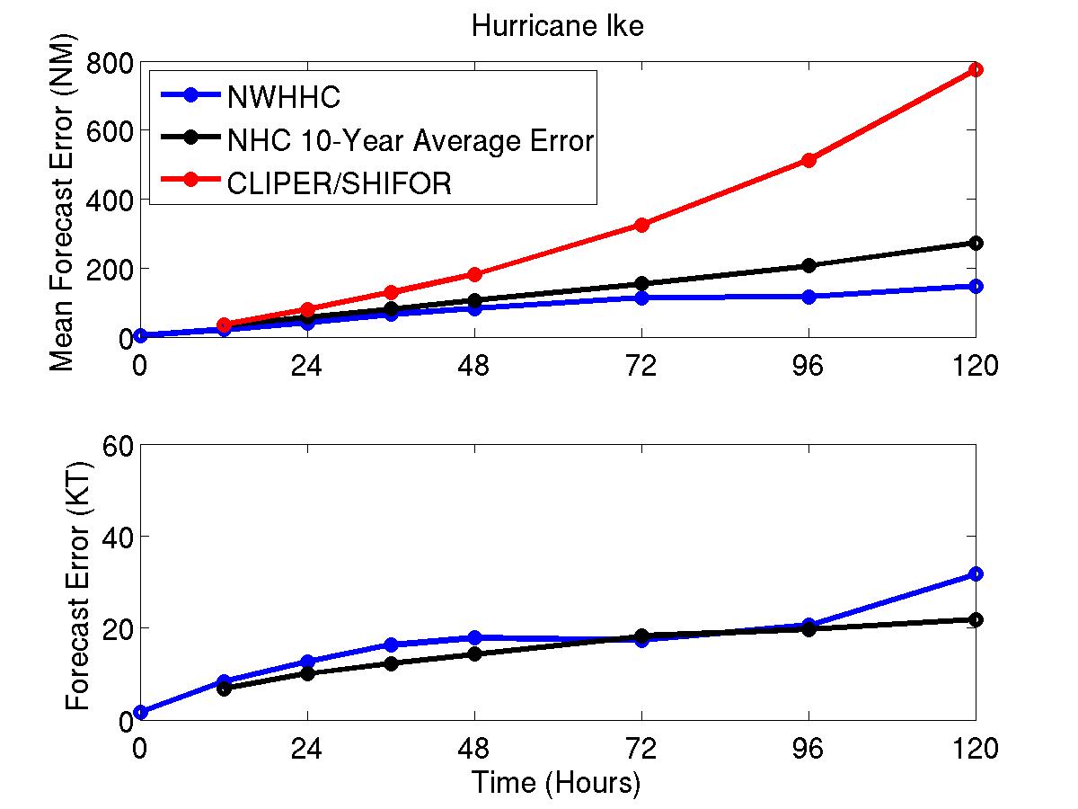
Figure 1: Mean track (top) and intensity (bottom) forecast errors for Hurricane Ike. Blue represents NWHHC forecasts, black, NHC 10-year mean, red CLIPER
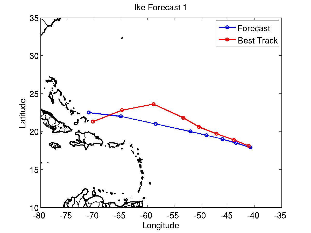
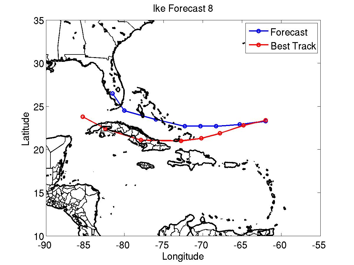
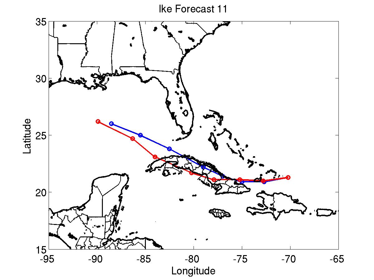
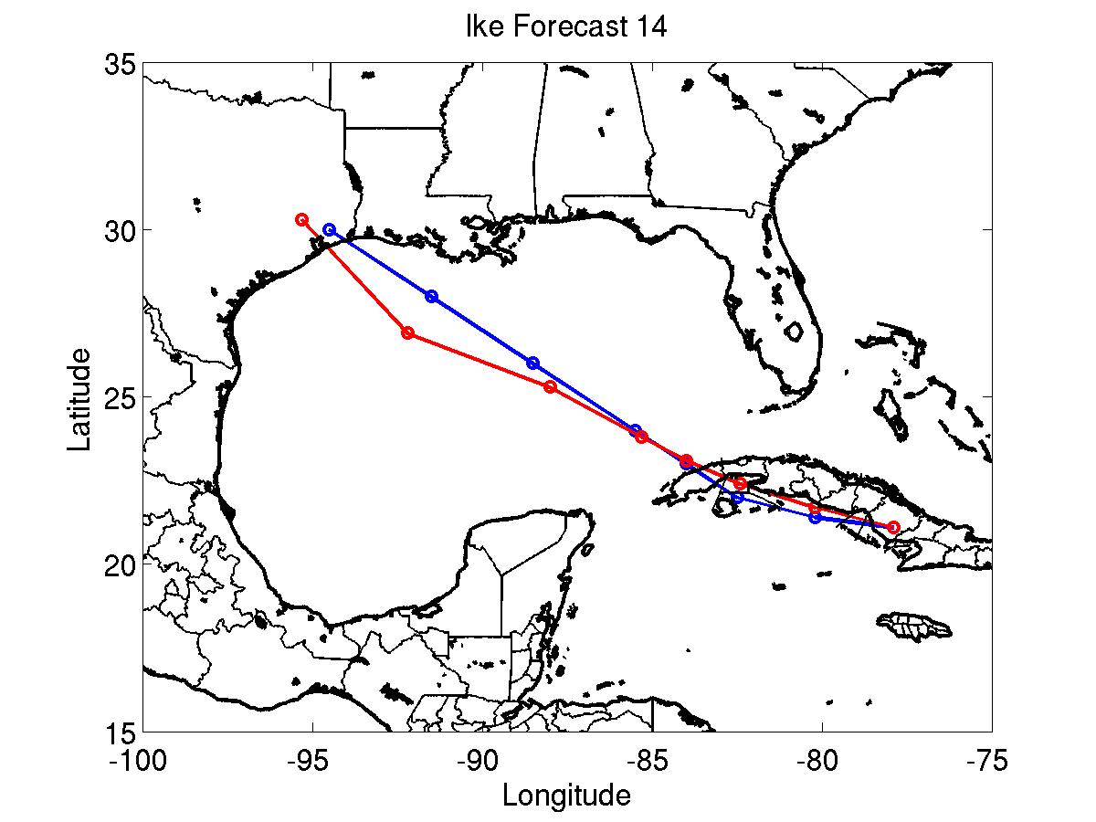
Selected track/intensity forecasts from Hurricane Ike. Blue line denotes the NWHHC forecast, the red the best track
Times when tropical storm/hurricane condition statements included in updates
9/6 1200 UTC: Hurricane conditions possible: SE Bahamas and Turks and Caicos Islands
9/7 0900 UTC: HURRICANE CONDITIONS EXPECTED: SE Bahamas and Turks and Caicos Islands
9/7 0900 UTC: Hurricane conditions possible: Central Bahamas, north coast of Cuba east of 78W
9/7 0900 UTC: Tropical storm conditions expected: North coast of Haiti and north coast of Dominican Republic west of 70W
9/7 2100 UTC: HURRICANE CONDITIONS EXPECTED: North coast of Cuba east of 78W
9/7 2100 UTC: Hurricane conditions possible: North coast of Cuba between 78-80W, south coast of Cuba east of 80W
9/7 1500 UTC: HURRICANE CONDITIONS EXPECTED: All of Cuba east of 80W
9/7 1500 UTC: Hurricane conditions possible: All of Cuba between 80-82W
9/7 1500 UTC: Hurricnae conditions no longer expected: Turks and Caicos Islands
9/7 1500 UTC: Tropical storm conditions no longer expected: Dominican Republic
9/7 2100 UTC: Hurricane conditions possible: Florida Keys
9/8 0300 UTC: HURRICANE CONDITIONS EXPECTED: All of Cuba between 80-82W
9/8 0300 UTC: Hurricane conditions possible: All of Cuba west of 82W
9/8 0300 UTC: Hurricane conditions no longer expected: SE Bahamas
9/8 0300 UTC: Tropical storm conditions no longer expected: Haiti
9/8 0900 UTC: HURRICANE CONDITIONS EXPECTED: All of Cuba between 82-83W
9/8 0900 UTC: Hurricane conditions no longer expected: Cuba east of 76W
9/8 0900 UTC: Hurricane conditions no longer possible: Central Bahamas
9/8 0900 UTC: Tropical storm conditions expected: Central Bahamas and Andros Island
9/8 1500 UTC: HURRICANE CONDITIONS EXPECTED: All of Cuba west of 77W
9/8 1500 UTC: Hurricane conditions no longer expected: Cuba east of 77W
9/8 1500 UTC: Tropical storm conditions no longer expected: Bahamas
9/8 2100 UTC: Hurricane conditions no longer expected: Cuba east of 78W
9/8 2100 UTC: Hurricane conditions no longer possible: Florida Keys
9/9 0300 UTC: Hurricane conditions no longer expected: Cuba east of 80W
9/9 0900 UTC: Hurricane conditions no longer expected: Cuba east of 81W
9/9 0900 UTC: Gale force winds expected: Florida Keys
9/9 1500 UTC: Hurricane conditions no longer expected: Cuba east of 82W
9/9 2100 UTC: Hurricane conditions no longer expected: Cuba east of 83W
9/10 0900 UTC: Hurricane and gale conditions no longer expected: All
9/11 0300 UTC: Hurricane conditions possible/tropical storm conditions expected: Mouth of Mississippi River to Texas/Louisiana Border
9/11 0300 UTC: Hurricane conditions possible: Texas/Louisiana Border to Baffin Bay, Texas
9/11 1500 UTC: Hurricane conditions possible/tropical storm conditions expected: Extended to Baffin Bay
9/11 2100 UTC: HURRICANE CONDITIONS EXPECTED: Matagorda, Texas to Morgan City, Louisiana
9/12 2100 UTC: Hurricane conditions no longer possible: Matagorda to Baffin Bay
9/13 0300 UTC: Tropical storm conditions no longer expected: Corpus Christi, Texas to Baffin Bay
9/13 0900 UTC: Hurricane and tropical storm conditions no longer expected or possible: Morgan City to mouth of Mississippi River
9/13 1300 UTC: Hurricane and tropical storm conditions no longer expected: Freeport, Texas to Corpus Christi, Morgan City to Texas/Louisiana Border
9/13 1500 UTC: Hurricane conditions no longer expected: Freeport to Texas/Louisiana Border
Click Here for individual track/intensity forecast error statistics
Back to Home Page