Hurricane Hanna Forecast Verification
Written by Derek Ortt on April 18, 2009
Track forecasts for Hurricane Hanna had a mean error greater than the NHC long-term mean. However they were significantly better than CLIPER. Figure 1 shows the mean track errors. The errors were the largest when Hanna made its loop from September 1-3. The track forecasts, as shown in Figure 2, did not indicate this loop. Instead, they mainly had a west to NW track. After completion of the loop, the forecasts were correctly able to indicate a final landfall in the Carolinas.
Intensity forecast errors were also greater than the long term mean. The strong shear during the loop was not initially expected. This led to some forecasts indicating that Hanna would reach category 2 status. Instead, Hanna proceeded to weaken to a tropical storm immediately after becoming a hurricane. Many forecasts also indicated that Hanna would strike the United States as a hurricane. This also did not verify. A possible reason was that the structure of Hanna was disrupted due to the shear and was not able to recover once it encountered more favorable conditions as it neared the coastline.
Updates indicated that tropical storm force winds were likely for the Bahamas a little more than 12 hours prior to their arrival. Little lead time was provided for Haiti due to the unexpected loop. For the United States, a statement indicating that tropical storm conditions were expected was inserted nearly 24 hours before landfall. This was due to the large size of the storm. The complete list is provided in the table below.
For synoptic history, and official watches and warnings, please see the National Hurricane Center Tropical Cyclone Report
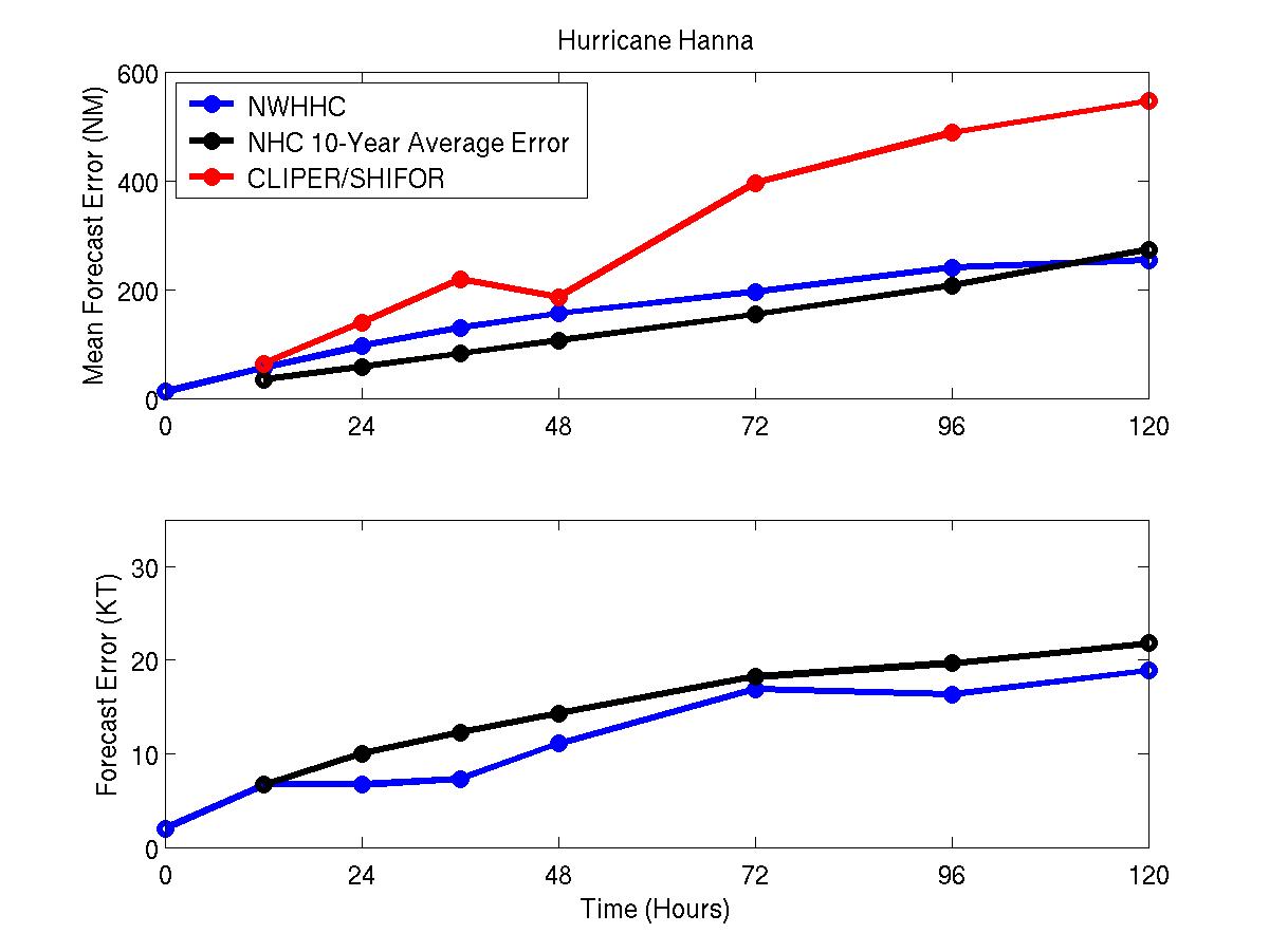
Figure 1: Mean track and intensity errors for Hurricane Hanna. The blue represents the NWHHC forecast, the red, CLIPER, and the black the NHC-10 year mean error.

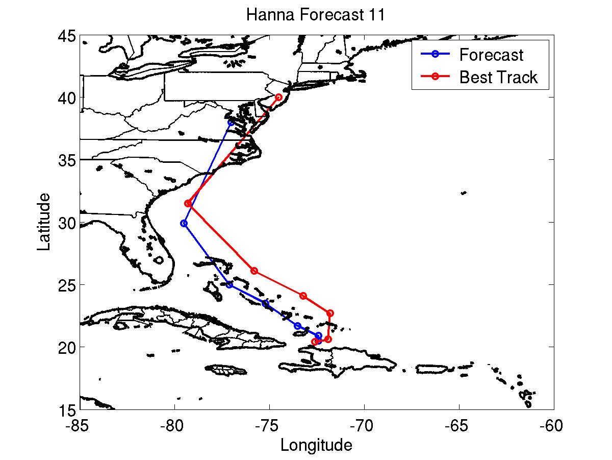
Track forecasts 5 (left) and 11 (right) for Hurricane Hanna. Blue represents the NWHHC forecast and the red the best track
Table of tropical storm/hurricane condition statements in updates
9/1 0300 UTC: Tropical storm conditions expected: Turks and Caicos Islands and SE Bahamas
9/1 1800 UTC HURRICANE CONDITIONS EXPECTED: Central Bahamas
9/1 1800 UTC: Hurricane conditions possible: NW Bahamas
9/2 0900 UTC: Hurricane conditions possible/Tropical Storm Conditions Expected: Northern Peninsula of Haiti
9/2 1500 UTC Hurricane conditions no longer expected of possible: Haiti and Central Bahamas
9/2 1500 UTC: Tropical storm conditions expected: Central Bahamas
9/3 0900 UTC: Tropical storm conditions expected: All of Haiti and north coast of Dominican Republic
9/3 0900 UTC: Hurricane conditions no longer possible: NW Bahamas
9/3 2100 UTC: Tropical storm conditions no longer expected: Haiti except for northern coast
9/4 0300 UTC: Tropical storm conditions no longer expected: Haiti and Dominican Republic
9/4 1500 UTC: Tropical storm conditions expected: NW Bahamas
9/4 1500 UTC: Tropical storm conditions no longer expected: Central and SE Bahamas and Turks and Caicos Islands
9/5 0900 UTC: Tropical storm conditions expected: Charleston, South Carolina to Cape Hatteras, North Carolina
9/6 0300 UTC: Tropical storm conditions expected: Cape Hatteras to Deleware Bay
9/6 0900 UTC: Tropical storm conditions expected: Deleware Bay to Atlantic City, New Jersey
9/6 0900 UTC: Tropical storm conditions no longer expected: Charleston to NC/SC Border
9/6 2100 UTC: Tropical storm conditions expected: Atlantic City, NJ to Cape Cod, MA
9/6 2100 UTC: Tropical storm conditions no longer expected: NC/SC Border to Cape Hatteras
9/7 0300 UTC: Tropical storm conditions expected: Cape Cop to East Port, Maine
9/7 0300 UTC: Tropical storm conditions no longer expected: Cape Hatteras to Cape May, NJ
9/7 0900 UTC: Tropical storm conditions no longer expected: All
Click Here for individual track/intensity forecast errors
Back to Verification Index