Hurricane Gustav Forecast Verification
Written by Derek Ortt on April 25, 2009
Track forecast errors for Hurricane Gustav were well below those of CLIPER and the long-term mean. Overall, Gustav was a fairly simple storm to forecast due to decent model agreement and a straight forward synoptic pattern. Figure 1 (top panel) shows the mean track forecast errors. There were two main sources of errors. The first was not anticipating the southward dip prior to striking Jamaica. This likely was due to a reformation of the center after crossing Haiti. The second was related to the forward speed once in the Gulf of Mexico. Gustav moved a little faster than initially forecast. Both of these errors are demonstrated in Figure 2, which shows track forecast #6. Gustav was expected to remain north of Jamaica and make U.S. landfall in about 120 hours. Instead, it made a landfall on Jamaica and U.S. landfall in about 108 hours.
Intensity forecast errors were generally above the long term mean. At the later time periods, this was primarily due to the track forecast being slower, keeping the storm over the water. This resulted in some intensity forecast errors of 70KT. A second reason was not anticipating the extent of the intensification as it approached Cuba. A third, but lesser reason was forecasting Gustav to strike Louisiana as a category 3 hurricane, underestimating the effect of the strong shear over the Gulf of Mexico.
Tropical storm and hurricane impact statements were included at the appropriate times. These are all listed in the table at the bottom.
For synoptic history, and official watches and warnings, please see the National Hurricane Center Tropical Cyclone Report
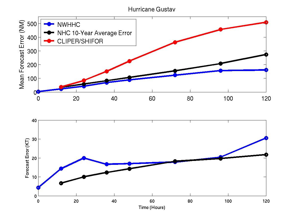
Figure 1: Mean track (top) and intensity (bottom) forecast errors for Hurricane Gustav. Blue represents NWHHC, black, long-term NHC mean, and red, CLIPER.
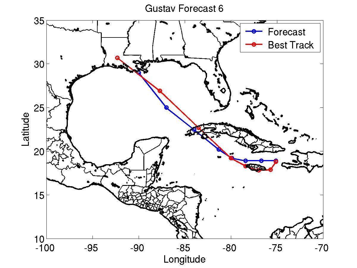
Gustav Track forecast #6. Blue is the NWHHC forecast and red is the best track.
Table of tropical storm/hurricane condition statements included in updates
8/25 1800 UTC: HURRICANE CONDITIONS EXPECTED: SW Peninsula of Haiti
8/25 1800 UTC: Hurricane conditions possible/Tropical storm conditions expected: All of Haiti except SW Peninsula, south coast of Dominican Republic west of 70W
8/26 0900 UTC: Hurricane conditions possible: Jamaica, Cuba east of 78W
8/26 1200 UTC: HURRICANE CONDITIONS EXPECTED: All of Haiti except NW Peninsula
8/26 1800 UTC: Hurricane and tropical storm conditions no longer expected or possible: Dominican Republic
8/26 2100 UTC: HURRICANE CONDITIONS EXPECTED: South coast of Cuba east of 78W
8/26 2100 UTC: Hurricane conditions Possible: Cuba from 78-80W
8/26 2100 UTC: Hurricane conditions no longer possible: Jamaica
8/27 0900 UTC: Hurricane conditions no longer expected: Haiti
8/27 0900 UTC: Tropical storm conditions expected: Haiti except NW Peninsula
8/27 1500 UTC: Hurricane conditions no longer expected: Cuba
8/27 1500 UTC: Hurricane and tropical storm conditions no longer expected or possible: NW Peninsula of Haiti
8/27 1500 UTC: Hurricane conditions no longer possible: North coast of Cuba east of 80W
8/27 1500 UTC: Hurricane conditions possible/Tropical storm conditions expected: South coast of Cuba east of 78W
8/27 2100 UTC: Hurricane conditions no longer possible: South coast of Cuba east of 78W
8/28 0000 UTC: Tropical storm conditions no longer expected: South coast of Cuba east of 76W
8/28 0000 UTC: Hurricane conditions no longer possible: Cuba
8/28 0300 UTC: Tropical storm conditions no longer expected: SW Peninsula of Haiti
8/28 0900 UTC: Tropical storm conditions expected: Jamaica
8/28 0900 UTC: Tropical storm conditions no longer expected: Cuba
8/28 1200 UTC HURRICANE CONDITIONS EXPECTED: Jamaica
8/28 1200 UTC: Hurricane conditions possible: Cayman Islands
8/29 0300 UTC: HURRICANE CONDITIONS EXPECTED: Cayman Islands
8/29 0300 UTC: Hurricane conditions no longer expected/Tropical storm conditions expected: Jamaica
8/29 0900 UTC: Hurricane conditions possible: Cuba west of 82W
8/29 2100 UTC: HURRICANE CONDITIONS EXPECTED: Cuba west of 83W
8/29 2100 UTC: Hurricane conditions possible/Tropical storm conditions expected: Cuba from 82-83W
8/30 0300 UTC: Tropical storm conditions no longer expected: Jamaica
8/30 0900 UTC: HURRICANE CONDITIONS EXPECTED: Cuba from 82-83W
8/30 0900 UTC: Hurricane conditions possible/Tropical storm conditions expected: Cuba 80-82W
8/30 0900 UTC: Hurricane conditions no longer expected: Grand Cayman Island
8/30 1500 UTC: HURRICANE CONDITIONS EXPECTED: Cuba from 81-82W
8/30 1800 UTC: Tropical storm conditions expected: Florida Keys south and west of Marathon
8/30 1800 UTC: Hurricane conditions no longer expected: Cayman Islands
8/31 0000 UTC: Hurricane conditions no longer expected: Isle of Youth, Cuba
8/31 0000 UTC: Hurricane conditions no longer possible: Cuba from 80-81W
8/31 0300 UTC: Hurricane conditions possible: Texas/Louisiana Border to Florida/Alabama Border
8/31 0300 UTC: Hurricane and tropical storm conditions no longer expected: Cuba east of 82.5W
8/31 0900 UTC: Hurricane conditions no longer expected: Remainder of Cuba
8/31 1200 UTC: HURRICANE CONDITIONS EXPECTED: Intracoastal City, Louisiana to Mobile, Alabama
8/31 1200 UTC: Hurricane conditions possible/Tropical storm conditions expected: Florida/Alabama Border to Ft. Walton Beach, Florida
8/31 1200 UTC: Tropical storm conditions no longer expected: Florida Keys
8/31 2100 UTC: HURRICANE CONDITIONS EXPECTED: Intracoastal City to Texas/Louisiana Border
9/1 1000 UTC: Hurricane conditions no longer possible: Mobile to Ft. Walton Beach
9/1 1700 UTC: Tropical storm conditions no longer expected: Mobile to Ft. Walton Beach
9/1 1700 UTC: Hurricane conditions no longer expected: Mississippi/Louisiana Border to Mobile
9/2 1700 UTC: Hurricane conditions no longer expected: All
Click Here for individual track/intensity verification statistics
Back to Verification Index