Tropical Storm Fay Forecast Verification
Written by Derek Ortt on June 17, 2009
The mean track forecast errors for Tropical storm Fay were below the long-term mean and CLIPER. However, some forecasts had very large error. The two main sources of error were not anticipating Fay turning NE and crossing Florida and not anticipating the slowing and loop east of Florida. The relatively slow forward speed during the loop served to reduce the mean absolute track errors. Figure 1 (top panel) shows the mean track error.
Intensity errors were also below the long-term mean. However, the bias that was present was that the forecasts indicated Fay would be more intense than it was when it struck Florida. Early forecasts even suggested the possible of a category 3 strike. The reason why this bias was present was that forecasts did not anticipate the SW shear due to an upper low as the storm crossed Cuba. Conditions improved as expected as the storm neared Florida. However, fay did not have enough time to reach hurricane intensity. The intensification over the Florida Peninsula was not expected; however, Fay remained just below hurricane intensity as it neared Lake Okeechobee.
Statements indicating tropical storm conditions expected were inserted at the proper times. A statement indicating hurricane conditions are expected was included for the Florida west coast. However, Fay did not reach hurricane intensity.
For synoptic history and official watches and warnings, please view the National Hurricane Center Tropical Cyclone Report
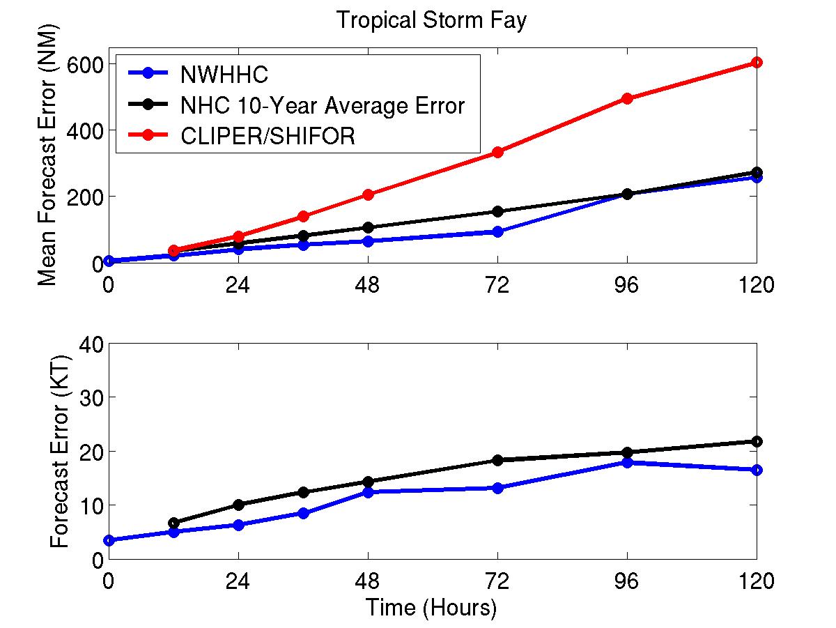
Figure 1: Mean track/intensity forecast errors for Tropical Storm Fay. Blue represents the NWHHC forecast, red the long-term mean, and black the best track.
Times when tropical storm/hurricane condition statements included in updates
8/15 2100 UTC: Tropical storm conditions expected: Dominican Republic
8/16 0000 UTC: Tropical storm conditions expected: Haiti
8/16 0300 UTC: Hurricane conditions possible: South coast of Cuba east of 83W
8/16 0900 UTC: Tropical storm conditions no longer expected: Dominican Republic
8/16 1500 UTC: Hurricane conditions no longer possible/Tropical storm conditions expected: South coast of Cuba east of 78W
8/16 1500 UTC: Hurricane conditions possible: Remainder of Cuba between 78-83W
8/17 0300 UTC: Tropical storm conditions no longer expected: Haiti
8/17 0900 UTC: Hurricane conditions posisble: Florida Keys
8/17 0900 UTC: Tropical storm conditions expected: South coast of Cuba between 80-78W
8/17 1500 UTC: Hurricane conditions no longer possible: All of Cuba
8/17 1500 UTC: Tropical storm conditions no longer expected: South coast of Cuba east of 76W
8/17 1500 UTC: Tropical storm conditions expected: All of Cuba between 82-76W
8/17 1800 UTC: Tropical storm conditions no longer expected: Cuba between 77-76W
8/17 2100 UTC: Tropical storm conditions expected: Cuba between 83-82W
8/18 0300 UTC: Hurricane conditions posisble: Florida west coast south of Ft. Myers
8/18 0300 UTC: Tropical storm conditions no longer expected: Cuba between 78-77W
8/18 0600 UTC: Tropical storm conditions no longer expected: Cuba between 79-78W
8/18 0900 UTC: Hurricane conditions posisble: Ft. Myers to Yankeetown
8/18 0900 UTC: Hurricane conditions no longer possible: Florida Keys
8/18 0900 UTC: Tropical storm conditions expected: Florida Keys, Florida west coast south of Naples
8/18 1200 UTC: tropical storm conditions expected: Florida east coast south of Palm Beach
8/18 1500 UTC: HURRICANE CONDITIONS EXPECTED: Ft. Myers to Ocean Reef
8/18 1500 UTC: Tropical storm conditions expected: Palm Beach to Vero Beach
8/18 2100 UTC: Tropical storm conditions expected: Lake Okeechobee
8/19 0300 UTC: Tropical storm conditions no longer expected: Florida keys south and west of Marathon
8/19 0900 UTC: Hurricane conditions no longer expected or possible: West coast of Florida
8/19 0900 UTC: Tropical storm conditions expected: Florida west coast south of Ft. Myers
8/19 1500 UTC: Tropical storm conditions expected: Vero Beach to St. Augustine
8/19 1500 UTC: Tropical storm conditions no longer expected: Florida Keys
8/19 2100 UTC: Hurricane conditions possible: Daytona Beach, Florida to Brunswick, GA
8/19 2100 UTC: Tropical storm conditions no longer expected: Florida east coast south of Palm Beach
8/19 2100 UTC: Tropical storm conditions no longer expected: Daytona Beach to St. Augustine
8/20 1200 UTC: Tropical storm conditions no longer expected: Florida west coast
8/20 1500 UTC: Hurricane conditions no longer possible: All
8/20 1500 UTC: Tropical storm conditions expected: Daytona Beach to Jacksonville
8/20 1500 UTC: Tropical storm conditions no longer expected: South of Vero Beach
8/22 0000 UTC: Tropical storm conditions expected: Yankeetown to St. Marks, Florida
8/22 1100 UTC: Tropical storm conditions expected: St. Marks to Panama City, Florida
8/22 2100 UTC: Tropical storm conditions expected: Destin, Florida to Panama City
8/22 2100 UTC: Tropical storm conditions no longer expected: Florida east coast south of Melbourne
8/23 0300 UTC: Tropical storm conditions expected: Ft. Walton Beach, Florida to Destin
8/23 0300 UTC: Tropical storm conditions no longer expected: Jacksonville to Melbourne
8/23 0900 UTC: Tropical storm conditions expected: Florida/Alabama Border to Ft. Walton Beach
8/23 1500 UTC: Tropical storm conditions no longer expected: Yankeetown to Horseshoe Beach
8/24 0300 UTC: Tropical storm conditions no longer expected: All
Click Here for individual track/intensity forecast error statistics
Back to Verification Index