Hurricane Noel Forecast Verification
Written by Derek Ortt on June 6, 2008
Track forecast errors for Hurricane Noel were above the NHC 10-year mean through 48 hours and below for the later time periods. However, they were better than those of CLIPER for all time periods. The mean errors are shown in the upper panel of Fig. 1. There three main reasons for the short term track errors. The first was due to difficulty in locating the center at the initial time period. Some initial position errors were greater than 60NM. This was due to the proximity to the mountains of Haiti and eastern Cuba, as well as the sheared state of the storm. The second was not forecasting the erratic short-term motion. However, this did not affect the long-term forecasts as the general large scale pattern was properly diagnosed. This is demonstrated in Fig. 2, which shows an unexpected NNW track across Haiti, followed by a west turn over Cuba, before the forecast recurvature. The third source of error was in the later forecasts due to indicating too much acceleration to the NE.
Intensity forecast errors were lower than the long-term mean and the SHIFOR. This is despite SHIFOR also having errors lower than the long-term mean. Rapid intensification was not expected until the system interacted with the trough while moving through the Bahamas. This was due to westerly vertical wind shear while in the Caribbean and land interaction.
Watches and warnings were generally recommended properly. A Hurricane Watch was briefly recommended for the NW Bahamas, but was dropped once the storm made landfall in Cuba. Watches and warnings were not recommended for New England and Canada due to the extra-tropical transition. Instead, updates indicated that conditions were possible or likely for certain areas.
For synoptic history and official watches and warnings, please see the National Hurricane Center Tropical Cyclone Report
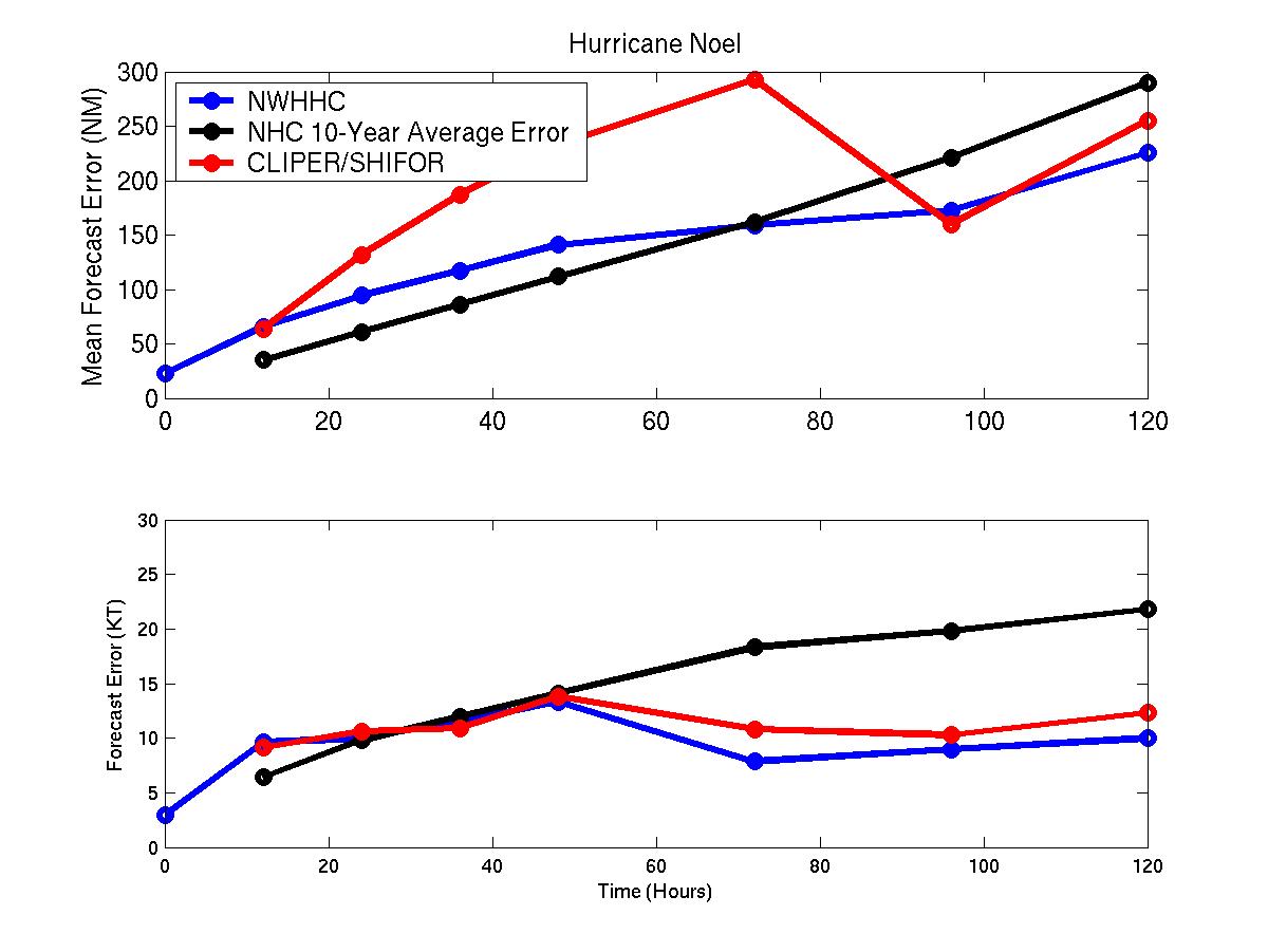
Mean track (upper) and intensity (lower) errors for Hurricane Noel. Blue denotes NWHHC forecast error, black denotes the 10-year mean NHC error, and red denotes the mean CLIPER/SHIFOR error.
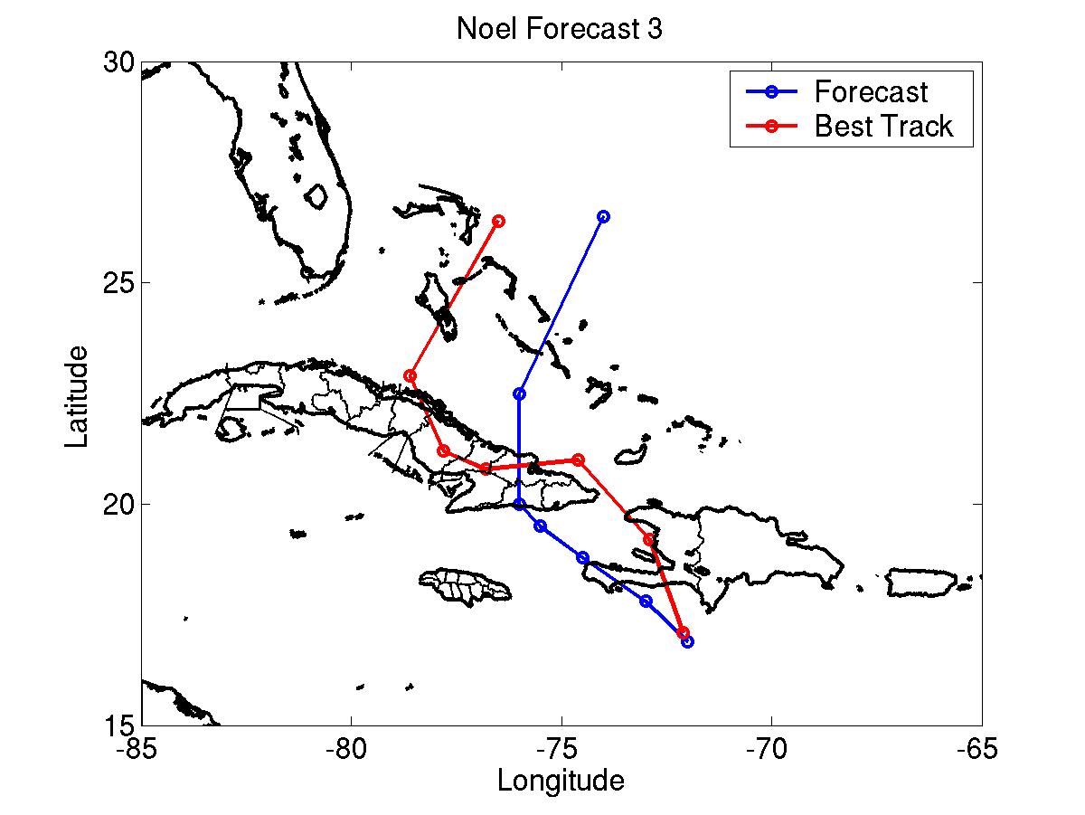
NWHHC track forecast #3 (blue) and best track (red).
Click Here for individual track/intensity error statistics.
Table of Recommended Watches and Warnings
0900 UTC 10/28 Tropical Storm Warning: South coast of Dominican Republic West of 70W
1500 UTC 10/28 Tropical Storm Warning: Haiti
0300 UTC 10/29 Tropical Storm Warning/Hurricane Watch: SW Peninsula of Haiti
0900 UTC 10/29 Tropical Storm Warning/Hurricane Watch to Tropical Storm Warning: SW Peninsula of Haiti
0900 UTC 10/29 Tropical Storm Warning: All of Dominican Republic
1500 UTC 10/29 Tropical Storm Warning: SE Bahamas
1500 UTC 10/29 Tropical Storm Warning Dropped: Haiti and Dominican Republic
2100 UTC 10/29 Tropical Storm Warning: Central Bahamas
0300 UTC 10/30 Tropical Storm Warning: North coast of Cuba east of 78W
0900 UTC 10/30 Hurricane Watch: NW Bahamas
1200 UTC 10/30 Tropical Storm Warning: All of Cuba east of 79W
1500 UTC 10/30 Hurricane Watch to Tropical Storm Warning: NW Bahamas
1500 UTC 10/30 Gale Warning: Islamorada, Florida to Melbourne, Florida
1500 UTC 10/31 Tropical Storm Warning Dropped: SE Bahamas and Cuba
0300 UTC 11/1 Gale Warning Dropped: Florida
0300 UTC 11/2 Tropical Storm Warning Dropped: Bahamas
Back to Verification Index