Hurricane Wilma Forecast Verification
Written by Derek Ortt on January 21, 2006
Track forecasts for Hurricane Wilma would have to be characterized as inconsistent. At times, the forecasts were well above average with 120 hour forecast errors being less than 100NM. However, at times, the 72-120 hour forecast errors were approaching 700-900NM.
There were three separate reasons for the track errors. The first was not capturing the southward dive in the Caribbean. While the 120 hour forecasts during this time were nearly perfect, the intermediate forecasts had larger than expected error and this had an impact on the long-term track as the recurvature was delayed. The second source of error was forecasting recurvature too soon. This caused several forecasts to have errors well above the long-term mean. In some cases, the 120-hour errors were in excess of 900NM. The third source of error was not depicting the acceleration of the storm to the NE soon enough. This resulted in forecast track being too slow, again leading to well above average errors. Despite this, there were numerous good forecasts. Forecast 12 was one of the better ones. This was the forecast about 72 hours prior to the closest pass to Key West and the track error was a mere 11NM.
Intensity forecast errors were above the average error in the short and intermediate term, but below the average error at 96 and 120 hours. This was due to the trend of significant intensification being depicted in the Caribbean being accurate, but underestimating the rate of intensification. For example, all forecasts indicated a category 4 hurricane in the Caribbean, even the initial forecast. However, the rate was under forecast to the point where there were 90KT errors at 12 and 24 hours. Even as the intensification was underway, the rate was not depicted in the initial intensity. One initial intensity error during the rapid intensification phase was 40KT. The intensification east of Florida also was not anticipated.
Watches and Warnings were recommended with very long lead times. The Hurricane Watch for the Yucatan was recommended about 3 days before landfall and the Warning about 36 hours before landfall. A super Hurricane Warning was recommended, but was dropped before landfall. In retrospect, it probably should have been remained in effect since Wilma hit with winds of 130KT and was intensifying as it moved inland. Operationally, Wilma was assessed to be a category 3 when the Warning was dropped, but dropsonde data indicated that surface winds were greater than flight level winds and were increasing at landfall. The Watch for the metro areas was recommended about 33 hours prior to the arrival of hurricane force winds and the Warning was recommended about 21 hours in advance. This was deemed to be enough lead time for a non storm surge event. The Warning for the keys was recommended about 27 hours before the onset of hurricane winds. A similar lead time was given for the NW Bahamas and Cuba.
For synoptic history, as well as the official watches and warnings, please see the National Hurricane Center Tropical Cyclone Report on Hurricane Wilma.
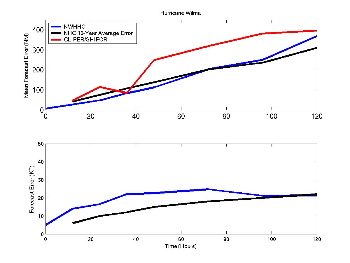
Track and intensity forecast errors for Hurricane Wilma
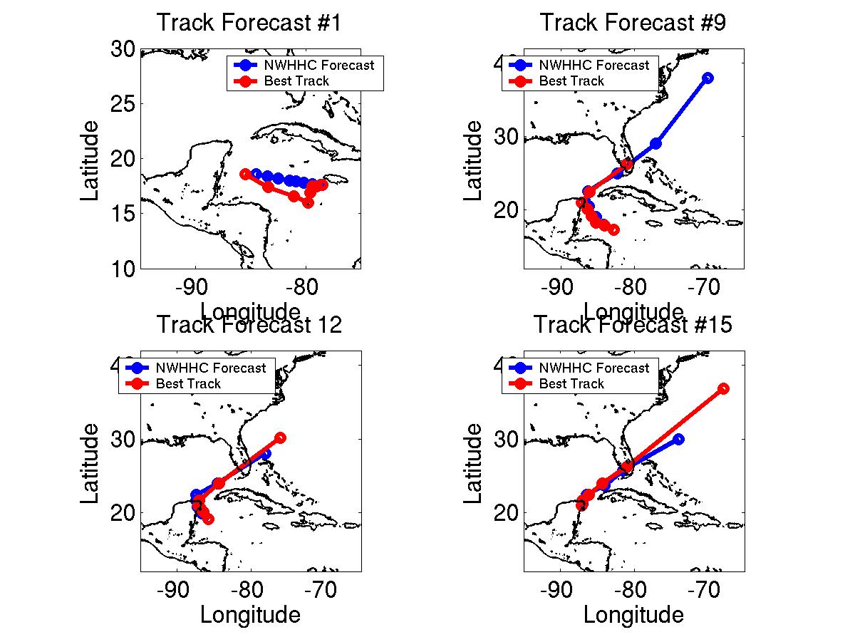
Selected track forecasts for Hurricane Wilma
Click Here for individual track and intensity error statistics.
Table of Recommended Watches and Warnings
10/16 2100 UTC Hurricane Watch: Cayman Islands
10/17 2100 UTC Hurricane Watch: Caribbean Coast of Honduras
10/18 2100 UTC Hurricane Watch: South Coast of Cuba West of 82W and Yucatan from Belize/Mexican Border to Cancun
10/19 2100 UTC Hurricane WARNING: Belize/Mexico Border to Cancun
10/19 2100 UTC Hurricane Watch: Cancun to Merida and all of Cuba west of 82W
10/19 2100 UTC Hurricane Watch Dropped: Cayman Islands and Honduras
10/20 0900 UTC Hurricane WARNING: Extended to Merida
10/20 0900 UTC Hurricane Watch: Merida to Campeche
10/20 2100 UTC SUPER HURRICANE WARNING: Cozemul Island
10/20 2100 UTC Hurricane WARNING: South Coast of Cuba west of 83W
10/21 0900 UTC SUPER HURRICANE WARNING: Cozemul Island to Cabo Catoche
10/21 0900 UTC Hurricane WARNING: Al;l of Cuba west of 83W
10/21 1800 UTC Super Hurricane Warning to Hurricane Warning: Cozemul to Cabo Catoche
10/21 1800 UTC Hurricane Warning Dropped: South of Tulum
10/22 1500 UTC Hurricane Watch: Florida Keys south and west of Marathon
10/22 1800 UTC Hurricane Watch: Florida west coast south of Tampa
10/23 0000 UTC Hurricane Watch Dropped: Merida to Campeche
10/23 0300 UTC Hurricane WARNING: Florida Keys south and west of Marathon and north coast of Cuba west of 81W
10/23 0300 UTC Hurricane Watch: Daytona Beach to Marathon, including Lake Okeechobee, and South Coast of Cuba from 81 to 83W, all of Cuba from 79-81W
10/23 0300 UTC Hurricane Warning to Tropical Storm Warning: Merida to Tulum
10/23 0900 UTC Hurricane WARNING: Florida west coast south of Tampa
10/23 0900 UTC Hurricane Watch: NW Bahamas
10/23 1500 UTC Hurricane WARNING: Lake Okeechobee, Melbourne to Marathon, and NW Bahamas
10/23 1500 UTC Tropical Storm Warning Dropped: Merida to Tulum
10/23 2100 UTC Hurricane WARNING: North coast of Cuba west of 80W
10/24 0900 UTC Hurricane Warning Dropped: Cuba
10/24 1300 UTC Hurricane Warning Dropped: Tampa to Sarasota
10/24 1500 UTC Hurricane Warning Dropped: Florida Keys south and west of Marathon
10/24 1700 UTC Hurricane Watch/Warning Dropped: Florida west coast, Dade/Broward Line to Marathon, north of Vero Beach
10/24 1800 UTC Hurricane Warning Dropped: Bade/Broward Line to Vero Beach
10/25 0000 UTC Hurricane Warning Dropped: NW Bahamas