Hurricane Rita Forecast Verification
Written by Derek Ortt on May 12, 2006
While the track forecasts for Hurricane Rita were better than the long-term average and much better than CLIPER, there were three major sources of error with the track forecasts.All three of these sources are for when Rita was in the Gulf of Mexico as forecasts prior to the storm moving into the Gulf were outstanding. The first of which was indicating a track too far to the south, resulting in many forecasts having a landfall in central or south Texas. The second source was that the track forecasts indicated a forward speed significantly higher that that observed, and the third was slowing the storm down over northern Louisiana and Arkansas after landfall, when the storm accelerated to the NE. Global model guidance slowed Rita down significantly after landfall and is primarily to blame for those errors. Overestimating the intensity of the subtropical ridge is to blame for the errors prior to landfall with the forward speed and heading.
Intensity forecast errors were larger than average for all time periods, except 120 hours. The primary reason for this is not anticipating Rita's intensification to 155KT over the Loop Current. This was not forecast by any of the forecast models. The amount of weakening after reaching peak intensity was also not anticipated.
Watches and warnings in general were recommended for the appropriate areas with an appropriate amount of lead time. The only unnecessary warnings were the Hurricane Warnings for the Bahamas, which in retrospect, should have been a Tropical Storm Warning/Hurricane Watch. The Warning for the Florida Keys and Cuba was recommended more than 24 hours before the closest pass of the eye. Hurricane winds only affected the lower Keys; thus, perhaps the Hurricane Warning for the northern Keys was unnecessary, though due to uncertainty in forecasting, it was warranted. A Watch was recommended for the Gulf Coast about 51 hours before landfall, and a warning about 30 hours prior. It should be noted that the eastern part of the Warning area was not under the initial recommended watch, due to the error in the forecast track.
For synoptic history, along with official watches and warnings, please see the National Hurricane Center Tropical Cyclone Report on Hurricane Rita
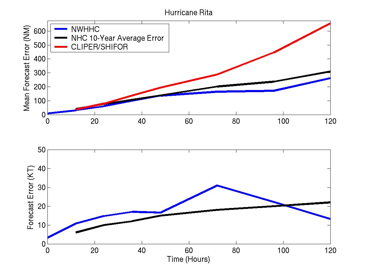
Figure 1: Track and intensity forecast verification for Hurricane Rita
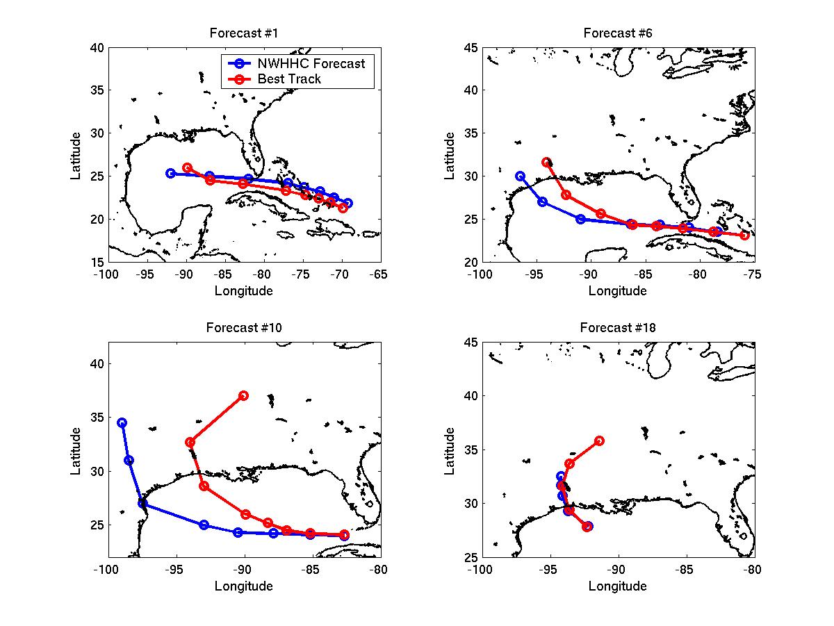
Figure 2: Selected track forecasts for Hurricane Rita
Click Here individual forecast error statistics
Table of Recommended Watches and Warnings
9/18 1200 UTC Hurricane Watch: NW Bahamas
9/18 1200 UTC Tropical Storm Warning: Central Bahamas
9/18 2100 UTC Hurricane Watch: Dade/Broward County Line to Marathon, FL
9/19 0000 UTC Hurricane WARNING: NW Bahamas
9/19 0300 UTC Hurricane WARNING: Central Bahamas
9/19 0300 UTC Hurricane Watch: Extended from Dade Broward Line to Palm Beach, FL
9/19 0300 UTC Hurricane Watch: FL west coast south of Naples and from Marathon to Dry Tortugas
9/19 1500 UTC Hurricane WARNING: Florida Keys from Key Largo to Marathon
9/19 2100 UTC Hurricane WARNING: Remainder of Florida Keys
9/19 2100 UTC Hurricane Watch/Tropical Storm Warning: North coast of Cuba between 80-83W and Dade County, FL
9/20 0000 UTC Hurricane WARNING: North coast of Cuba between 80-83W
9/20 0000 UTC Hurricane Warning Dropped: Central Bahamas
9/20 1500 UTC Hurricane Watch to Tropical Storm Warning: Palm Beach to Dade Broward Line and FL west coast south of Naples
9/20 1500 UTC Hurricane Warning Dropped: NW Bahamas
9/20 1700 UTC Hurricane Watch/Tropical Storm Warning to Tropical Storm Warning: Dade County
9/20 2100 UTC Hurricane Warning to Tropical Storm Warning: Key Largo to Marathon
9/20 2100 UTC Hurricane Warning Dropped: North coast of Cuba between 80-81W
9/20 2100 UTC Tropical Storm Warning Dropped: Florida Mainland
9/21 0000 UTC Hurricane Warning Dropped: North Coast of Cuba between 81-82W
9/21 0300 UTC Hurricane Warning to Tropical Storm Warning: Marathon to Dry Tortugas
9/21 0300 UTC Hurricane Warning Dropped: Cuba
9/21 0300 UTC Tropical Storm Warning Dropped: Key Largo to Marathon
9/21 0900 UTC Tropical Storm Warning Dropped: Marathon to Dry Tortugas
9/22 0300 UTC Hurricane Watch: Texas/Mexico Border to Intracoastal City, Louisiana
9/23 0000 UTC Hurricane WARNING: Port O'Connor, TX to Morgan City, LA
9/23 0000 UTC Hurricane Watch: Morgan City to Mouth of Mississippi River
9/23 0000 UTC Hurricane Watch Dropped: South of Port Mansfield, TX
9/23 0500 UTC Hurricane Watch Dropped: South of Corpus Christi, TX
9/23 0900 UTC Hurricane Watch/Tropical Storm Warning: Corpus Christi to Port O'Connor and Morgan City to Mouth of Mississippi River
9/23 2100 UTC Hurricane Warning to Hurricane Watch/Tropical Storm Warning: Port O'Connor to Freeport, TX
9/24 0600 UTC Hurricane Watch/Tropical Storm Warning to Tropical Storm Warning: Morgan City to mouth of Mississippi River
9/24 0600 UTC Hurricane Watch/Tropical Storm Warning Dropped: Port O'Connor to Freeport
9/24 0900 UTC Hurricane Warning Dropped: South and west of Galveston, TX
9/24 0900 UTC Tropical Storm Warning Dropped: East of Morgan City
9/24 1100 UTC Hurricane Warning Dropped: Galveston to Morgan City
Back to Verification Index