Hurricane Ophelia Forecast Verification
Written by Derek Ortt on February 6, 2006
Track forecast errors at all time periods were below the NHC 10-year average, and well below those of CLIPER, indicating that, in general, track forecasts had skill. However, there were some large errors, especially during the times when the hurricane was close to North Carolina. The source of this error was a failure to capture the slowing just south of Cape Hatteras. Instead, the forecasts indicated an immediate NE acceleration. A second source of error was during the looping period when forecasts indicated that the hurricane would make landfall; however, the majority of these errors were below the long-term mean.
Intensity forecast errors were also below the long-term mean and would have been even better had the track forecasts not indicated a landfall over the Carolinas, as this yielded errors approaching 40-50KT for selected forecasts. In addition, the intensification to 75KT near North Carolina was not well anticipated.
A Tropical Storm Warning was recommended briefly for Florida due to tropical storm force winds very near or on the coast for a short period of time. Greater lead time is needed in the future. The watches for the Carolinas were more irregular due to the erratic motion. A Hurricane Watch was recommended on 9/10, but was dropped on 9/11 since the storm was looping and not an immediate threat. The plan was to recommended a hurricane Watch again on 9/12; however, Ophelia weakened and the wind field expanded. Therefore, a Tropical Storm Warning was recommended. This was changed to a Hurricane Warning at 0000 UTC, 9/13 when Ophelia showed signs of re-intensification. This still provided more than 24 hours notice for Cape Fear and more than 36 hours notice for the Morehead City area. The Hurricane Watches and Warnings north of Cape Hatteras proved to be unnecessary.
For synoptic history, as well as official watches and warnings, please see the National Hurricane Center Tropical Cyclone Report on Hurricane Ophelia.
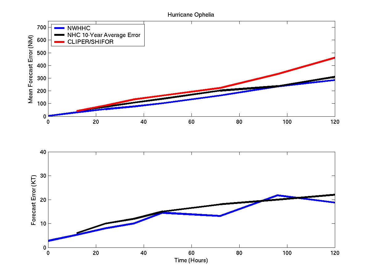
Mean track/intensity forecast errors for Hurricane Ophelia
Click Here for individual forecast error statistics.
Table of Recommended Watches and Warnings
9/8 2100 UTC Tropical Storm Warning: Palm Bay to Flaglar Beach, Florida
9/9 0300 UTC Tropical Storm Warning dropped: Palm Bay to Flaglar Beach
9/10 1500 UTC Hurricane Watch: Hilton Head Island, SC to Kitty Hawk, NC
9/11 0300 UTC Hurricane Watch: Extended to NC/VA Border
9/11 0300 UTC Hurricane Watch Dropped: South of Myrtle Beach, SC
9/11 1200 UTC Hurricane Watch Dropped: Hurricane Watch Area
9/12 1800 UTC Tropical Storm Warning: Charleston, SC to Cape Hatteras, NC
9/13 0000 UTC Hurricane WARNING: Myrtle beach to Cape Hatteras
9/13 0000 UTC Hurricane Watch: Cape Hatteras to NC/VA Border
9/14 0000 UTC Hurricane WARNING: Extended to NC/VA Border
9/14 0000 UTC Hurricane Watch Extended: North to Mouth of Chesepaeke bay
9/14 1500 UTC Hurricane WARNING: Extended to Mouth of Chesepaeke Bay
9/14 1500 UTC Hurricane Watch: Chesepaeke Bay to Delaware Bay
9/14 1500 UTC All Warnings Dropped: South of NC/SC Border
9/15 0000 UTC Hurricane Warning Dropped: West of Cape Fear
9/15 0600 UTC Hurricane Warning Dropped: South and west of Topsail Beach
9/15 0900 UTC Hurricane Warning Dropped; South and west of Jacksonville, NC
9/15 1200 UTC hurricane Warning Dropped: South and west of Morehead City
9/16 0000 UTC All Watches and Warnings Dropped
9/17 0300 UTC Tropical Storm Warning: Bedford, MA to Plymouth, MA
9/17 1000 UTC Tropical Storm Warning: Nova Scotia west of Halifax
9/17 1500 UTC Tropical Storm warning Dropped: MA Coast
9/17 1800 UTC Tropical Storm Warning: All of Nova Scotia and Prince Edward Island
9/18 0300 UTC Tropical Storm Warning Dropped: All