Hurricane Katrina Forecast Verification
Written by Derek Ortt on January 4, 2006
Forecasting the future track of Katrina posed little difficulty. Only one, of 18 forecasts had above average error, and that was related to the forward motion. At all time periods, the track forecasts for Hurricane Katrina were well below the 10-year National Hurricane center mean forecast error (the long-term standard), and well below the CLIPER model, the basis for determining whether or not a track forecast has any skill. At the 120 hour time period, the mean NWHHC forecast error was about 50 percent less than the 10-year NHC average, and about 75 percent of the CLIPER error. The verification, while not as good at the shorter time periods, still indicated that the forecasts had a high degree of skill. it should be noted that no forecasts took Katrina over or west of New Orleans. Instead, all forecasts correctly indicated a pass just east of the city.
On the other hand, the intensity forecasts left a lot to be desired. At the 72 hour time period, the mean forecast error was 48.7KT, more than 250 percent the long term mean. There were three reasons for this large forecast error. The first was keeping Katrina over the Florida Peninsula too long, which resulted in additional weakening that was observed in the forecast. The second was not weakening the hurricane quick enough after final landfall and keeping the hurricane over the Gulf of Mexico too long. The third was not anticipating the rapid intensity changes immediately after the hurricane emerged into the Gulf of Mexico or as the hurricane moved over the shelf waters of the northern Gulf of Mexico. In retrospect, these changes should have been anticipated due to the hurricane passing over very high oceanic heat content of the loop current after emerging into the Gulf of Mexico and over very low heat content over the shelf waters of the northern Gulf.
The recommended watches and warnings for Florida were not sufficient. The initial Hurricane warning was recommended in plenty of time, more than 24 hours prior to landfall. However, the zone of Coral Gables to Vero Beach was inappropriate. This was due to the track forecasts being slightly north of the observed track, and an expectation of hurricane conditions remaining north of the center. Instead, the hurricane moved south of the forecast track, and hurricane conditions were confined south of the center. A Hurricane warning was not recommended for south of Coral Gables until 2200 UTC, 8/25, just a couple of hours before the worst of the weather. While it is not known if sustained hurricane winds occurred south of Coral Gables, gusts to 84KT were reported in Homestead; thus, the warning should have been recommended earlier. The Hurricane warning for the Keys was also late and sustained hurricane winds occurred at the Dry Tortugas.
A Tropical Storm Warning should have been recommended for Cuba as sustained tropical storm winds occurred. This was considered at the time, but incorrectly, it was decided not to recommend any warnings for Cuba.
The Watches and Warnings were appropriate for the Gulf Coast and all had the appropriate lead time. Even though the hurricane weakened unexpectedly to a category 3, the super hurricane warning still served a purpose as the storm surge that occurred in Mississippi was the highest ever recorded in the United States. This was the first time a Super Hurricane Warning was recommended for the United States by NWHHC (in service since 2002).
For synoptic history, as well as the official watches and warnings, please see the National Hurricane Center Tropical Cyclone Report for Hurricane Katrina.
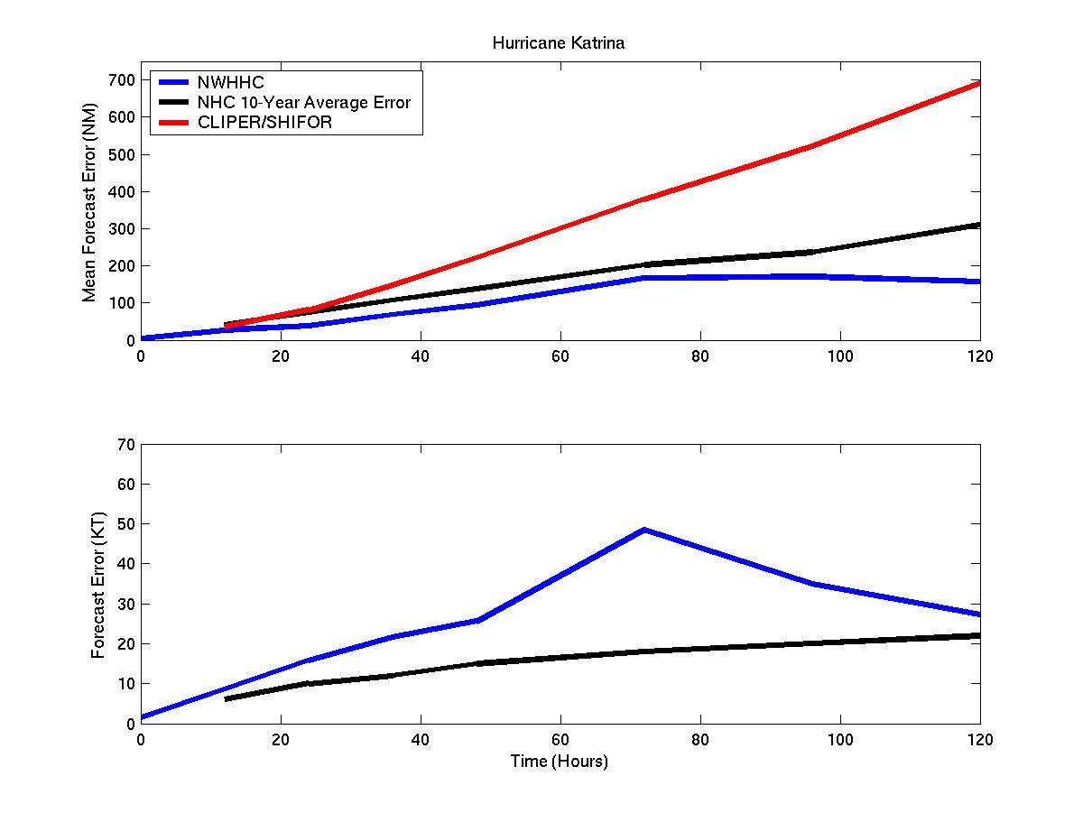
Mean track and intensity forecast errors for Hurricane Katrina
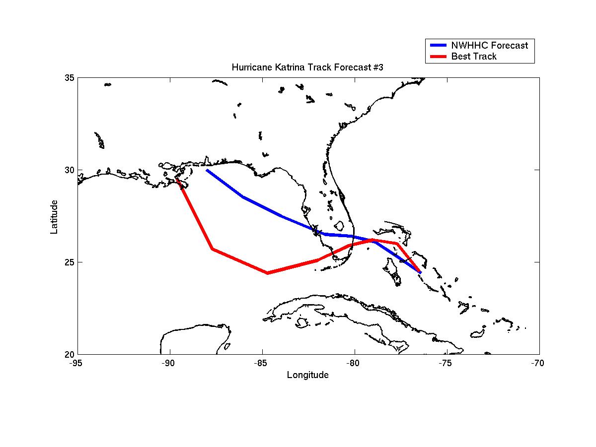
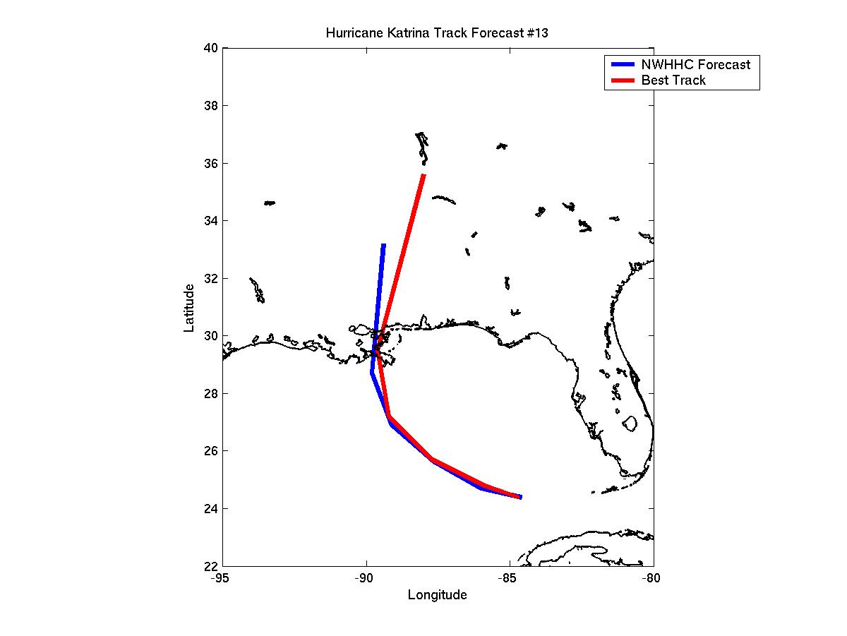
Track Forecasts 3 and 13
Click Here for the forecast error statistics
Table of Recommended Watches and Warnings
8/23 2100 UTC Tropical Storm Warning: Central Bahamas
8/24 1200 UTC Tropical Storm Warning: NW Bahamas
8/24 1500 UTC Hurricane Watch: Islamorada, FL to Vero Beach, FL
8/24 2100 UTC Hurricane WARNING: Coral Gables, FL to Vero Beach
8/24 2100 UTC Hurricane Watch: Lake Okeechobee
8/25 0300 UTC Hurricane WARNING Lake Okeechobee
8/25 1900 UTC Tropical Storm Warning Dropped: Central Bahamas
8/25 2200 UTC Hurricane WARNING: Extended from Coral Gables to Key Largo
8/26 0100 UTC Tropical Storm Warning: West Coast of Florida south of Port Charlotte
8/26 0300 UTC Hurricane WARNING: West Coast of Florida south of Ft Myers and all of the Florida Keys
8/26 0300 UTC Hurricane Warning Dropped: North of Palm Beach
8/26 0300 UTC Tropical Storm Warning Dropped: NW Bahamas
8/26 0700 UTC Hurricane Warning Dropped: North of Florida City
8/26 0700 UTC Tropical Storm Warning: Florida City to Dade/Broward Line
8/26 1500 UTC All Watches and Warnings Dropped: North of Islamorada
8/27 0300 UTC Hurricane Warning Dropped: All
8/27 0300 UTC Tropical Storm Warning: Marathon to Dry Tortugas
8/27 1500 UTC Hurricane Watch: Cameron, Louisiana to Destin, FL
8/27 1500 UTC Tropical Storm Warning Dropped: Florida Keys
8/28 0300 UTC Hurricane WARNING: Destin, Florida to Intracoastal City, Louisiana
8/28 0300 UTC Hurricane Watch: Destin to Panama City
8/28 2100 UTC SUPER HURRICANE WARNING: Grand Isle, Louisiana to Mississippi/Alabama Border
8/29 1500 UTC Hurricane WARNING: Morgan City, Louisiana to Destin
8/29 1500 UTC: All Watches/Warnings Dropped: Outside of new Hurricane Warning area
8/29 1900 UTC: Hurricane Warning Dropped: West of Grand Isle and east of Pensacola
8/29 2100 UTC: Hurricane Warning Dropped: Gulf Coast
Back to Verification Index