Hurricane Emily Forecast Verification
Written by Derek Ortt on March 16, 2006
The track forecasts for Hurricane Emily were outstanding. The only significant source of error was in the first two forecasts, where the effects of a low-level easterly wind surge were not correctly indicated; thus, the forecasts were far too slow. However, once this was identified, the forecast quality improved. A second, though lesser, source of error was not anticipating the slowing near and over northern mainland Mexico. In fact, there were 5 day forecasts that had errors of less than 100NM, with one under 30NM. it should be noted that the CLIPER errors were below the long-term mean; thus, Emily was not a difficult storm to forecast.
Intensity forecasts struggled some. The intensification into a hurricane prior to landfall at Grenada was initially forecast, then the forecast changed due to a disorganized appearance. The intensification into a category 5 hurricane was not correctly forecast. In fact, forecasts indicated a slow weakening over the western Caribbean as the environment appeared to be somewhat unfavorable for intensification. Instead, the upper low that was expected to shear the system, moved to the west along with the hurricane, allowing for conditions to remain favorable for development. Forecasts for the Gulf of Mexico landfall, in general, accurately forecast the intensification into a major hurricane.
Some comment is necessary on the recommended watches and warnings. A Hurricane Watch was recommended for the Lesser Antilles more than 36 hours prior to the arrival of the hurricane. This was upgraded to a Hurricane Watch/Tropical Storm Warning 12 hours later. Initially, it was planned to recommend a Hurricane Warning at this time; however, Emily appeared disorganized on satellite imagery. At 1230 UTC, 7/13, this was downgraded to a Tropical Storm Warning, again due to the poor satellite appearance. Emily was expected to move through the islands with winds of 45-50KT. A couple of hours later, recon data indicated that Emily had begun to intensify, and had winds of 50KT, and updates stated that further intensification was possible, but hurricane intensity was unlikely. In retrospect, a Tropical Storm Warning/Hurricane Watch should have been recommended (see http://www.nwhhc.com/gpage4.html for the differences between a Tropical Storm Warning/Hurricane Watch and a Hurricane Watch/Tropical Storm Warning). A Hurricane Warning was then recommended at 0300 UTC 7/14, just four hours before landfall and in the middle of the night for the islands expected to receive hurricane conditions. This could have been recommended two hours before when recon was indicating that the winds were very near hurricane intensity.
Hurricane Warnings for Jamaica, Grand Cayman, and Texas proved to be unnecessary and a Hurricane Watch/Tropical Storm Warning would have been sufficient.Other watches and warnings had the appropriate lead times.
For synoptic history, and official watches and warnings, please see the National Hurricane Center Tropical Cyclone Report on Hurricane Emily.
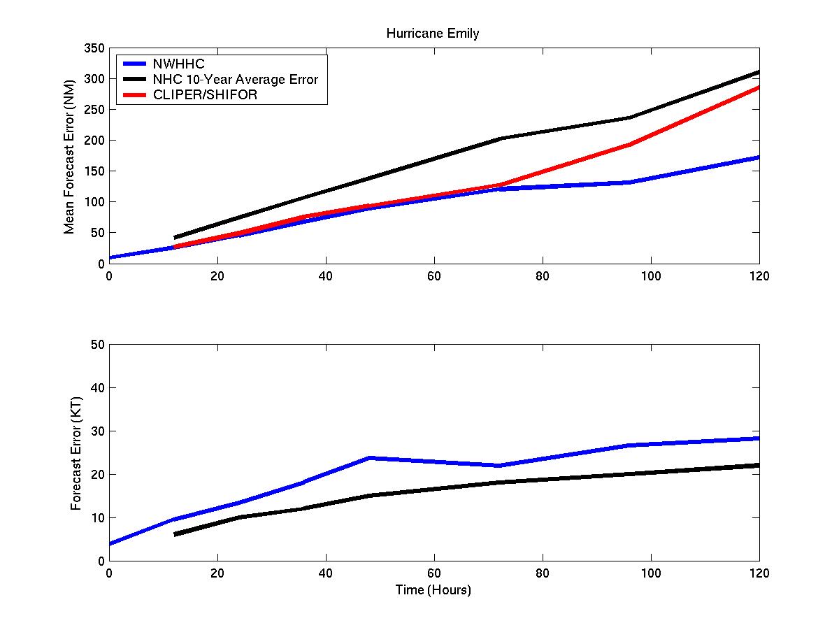
Mean track and intensity forecast errors for Hurricane Emily
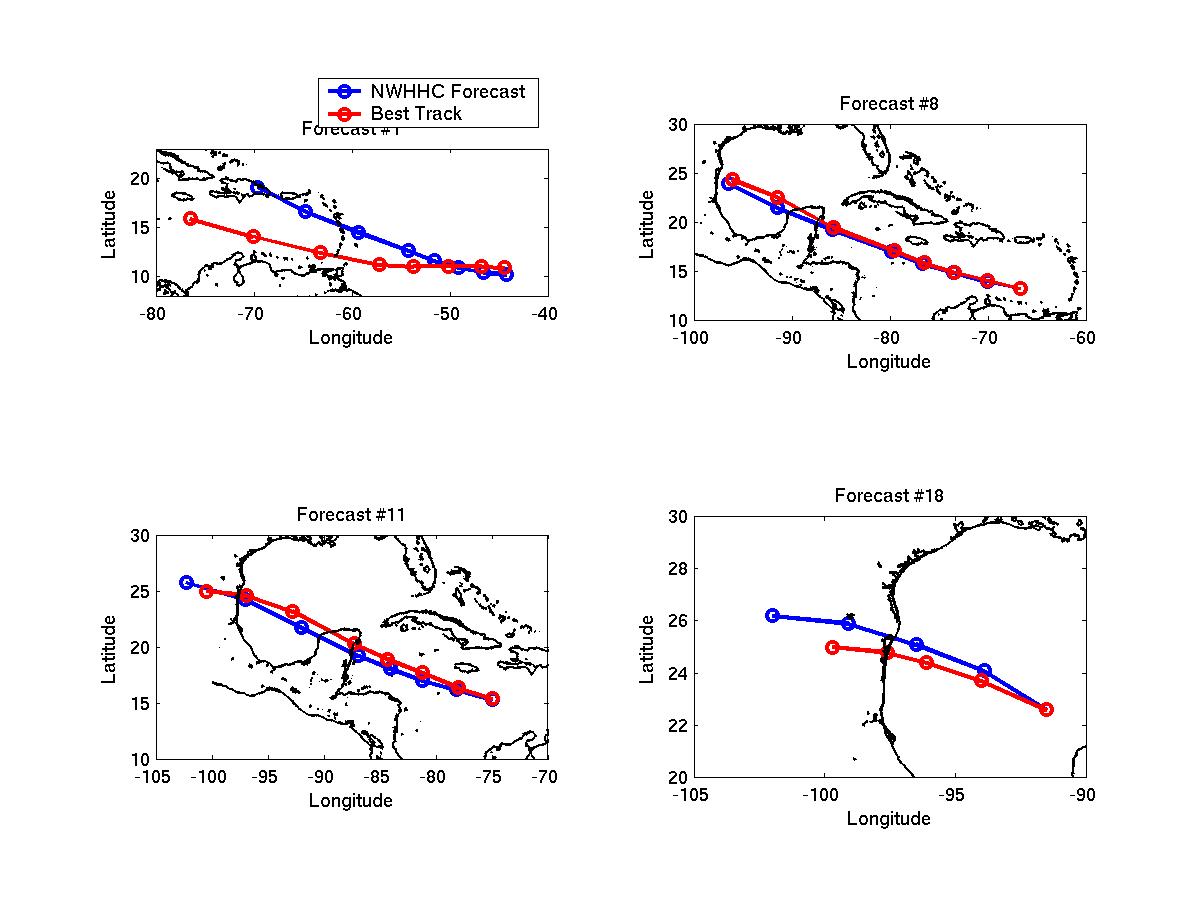
Selected track forecasts for Hurricane Emily
Click Here for individual track/intensity forecast errors.
Table of Recommended Watches and Warnings
7/12 1500 UTC Hurricane Watch: Grenada to Guadeloupe, including Barbados
7/13 0300 UTC Hurricane Watch/Tropical Storm Warning: Trinidad and Tobago through St Lucia
7/13 0300 UTC Hurricane Watch: Caribbean Coast of Venezuela east of 66W
7/13 0300 UTC Hurricane Watch Dropped: North of St Lucia
7/13 1230 UTC Hurricane Watch/Tropical Storm Warning to Tropical Storm Warning: Trinidad and Tobago to St Lucia
7/13 1230 UTC Hurricane Watch Dropped: Caribbean coast of Venezuela
7/13 1500 UTC Tropical Storm Warning: Caribbean coast of Venezuela east of 64W
7/14 0300 UTC Hurricane WARNING: Grenada, the Grenedines, and St Vincent
7/14 0900 UTC Tropical Storm Warning Dropped: Windward Islands not under a Hurricane Warning
7/14 1200 UTC Tropical Storm Warning Extended: To Caribbean Coast of Venezuela east of 65W
7/15 0000 UTC Hurricane Watch: Jamaica
7/15 0000 UTC Tropical Storm Warning Dropped: Venezuela
7/15 0900 UTC Hurricane WARNING: Jamaica
7/15 0900 UTC Hurricane Watch: Cayman Islands
7/16 0900 UTC Hurricane Watch/Tropical Storm Warning: Cayman Islands
7/16 1500 UTC Hurricane Watch: Belize/Guatemala Border to Cancun, Mexico
7/16 1800 UTC Hurricane WARNING: Grand Cayman Island
7/17 0000 UTC Hurricane Warning Dropped: Jamaica
7/17 0300 UTC Hurricane WARNING: Chetumal, Mexico to Cancun
7/17 0300 UTC Hurricane Watch: Cancun to Campeche, Mexico
7/17 0600 UTC Hurricane Watch Dropped: Belize
7/17 0900 UTC Hurricane Warning to Tropical Storm Warning: Grand Cayman Island
7/17 0900 UTC Hurricane Watch/Tropical Storm Warning Dropped: Little Caymand and Cayman Brac
7/17 1500 UTC Hurricane WARNING: Cancun to Campeche
7/17 1500 UTC Tropical Storm Warning Dropped: Grand Cayman
7/18 0900 UTC Hurricane Watch: Tampico, Mexico to Corpus Christi, Texas
7/18 1200 UTC Hurricane Warning Dropped: Chetumal to Cancun
7/18 2100 UTC Hurricane WARNING: Tampico to Port Mansfield, Texas
7/18 2100 UTC Hurricane Warning Dropped: Cancun to Campeche
7/20 1500 UTC Hurricane Watch Dropped: Port Mansfield to Corpus Christi
7/20 2100 UTC Hurricane Warning Dropped: Tampico to Port Mansfield
Back to Verification Index