Hurricane Jeanne Forecast Verification
Written by Derek Ortt on April 24, 2005
Track forecasts for Hurricane Jeanne for the 12-72 hour time periods were significantly better than were the long-term averages. However, the 96 and 120 hour forecasts were slightly worse. The reason for this was because the looping motion was not well anticipated in advance. In addition, the acceleration toward the coast of Florida was not immediately anticipated.
Figures 2 and 3 show forecasts 15 and 17. Forecast 15 was the forecast roughly 72 hours prior to landfall. While the error was less than 100NM, that forecast indicated a turn just prior to reaching the coast and a landfall in the Carolinas. This shows the difficulty in long-range tropical cyclone forecasting. Two forecasts later and for all other forecasts, the track forecasts brought Jeanne into Florida, though there was a slight southward bias. It should be noted that after the looping motion was begun, the track forecasts through 72 hours were extremely good.
Intensity forecasts were below the long-term averages for most of the time periods. The near dissipation over Hispaniola was not anticipated, nor was the intensification into a major hurricane foreseen long in advance. The third source of error was keeping the storm offshore for too long.
Forecasts beginning a couple of days before landfall did accurately forecast a landfalling major hurricane. Forecasts within 24 hours of landfall indicated a landfalling category four hurricane; however, this did not materialize, likely due to an unexpected eye wall replacement cycle.
For synoptic history, as well as the official watches and warnings, please see the National Hurricane Center Tropical Cyclone Report for Hurricane Jeanne
Click Here for Verification Statistics
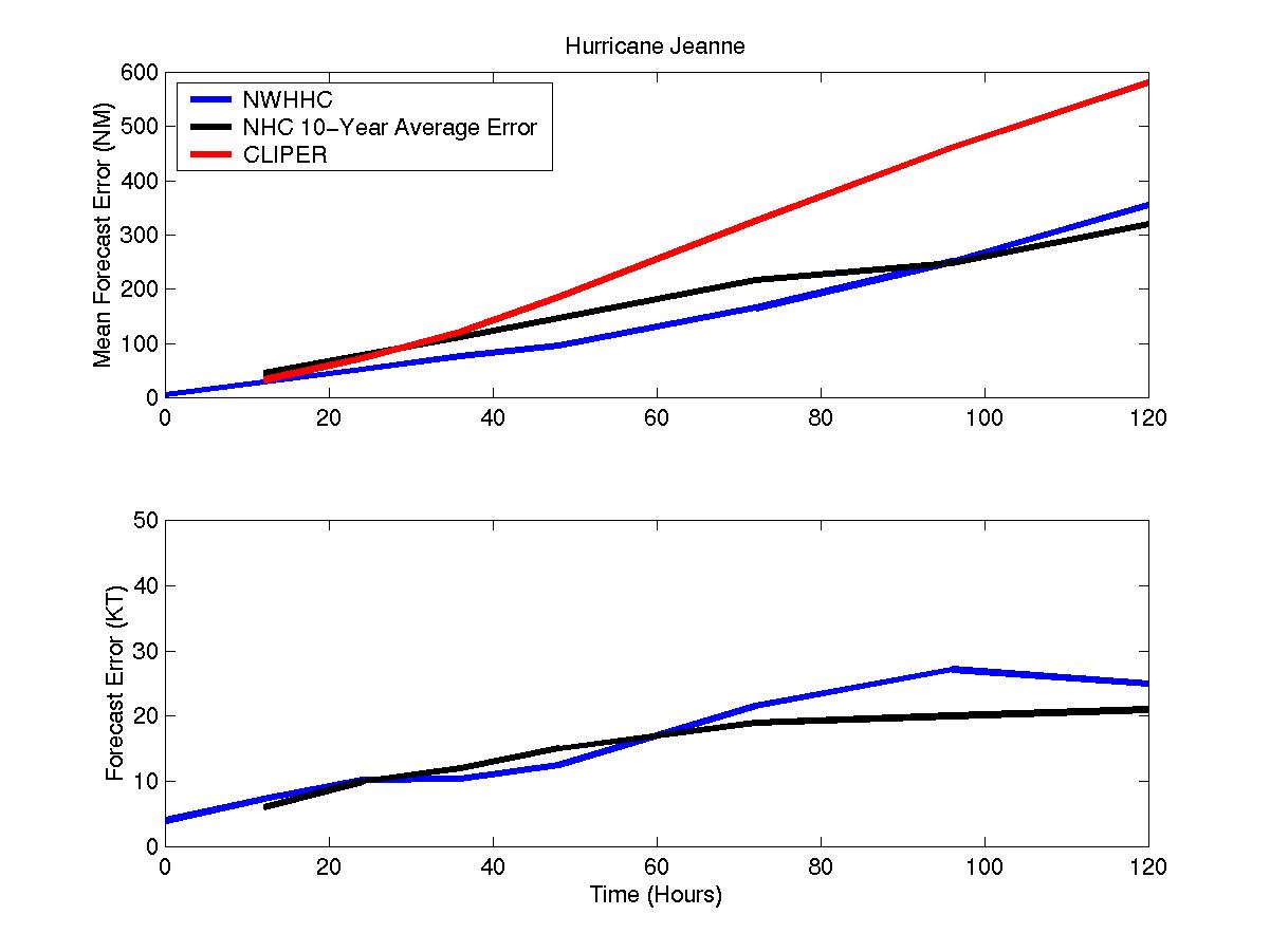
Figure 1: Mean Forecast Errors for Hurricane Jeanne
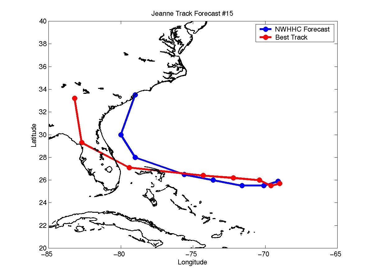
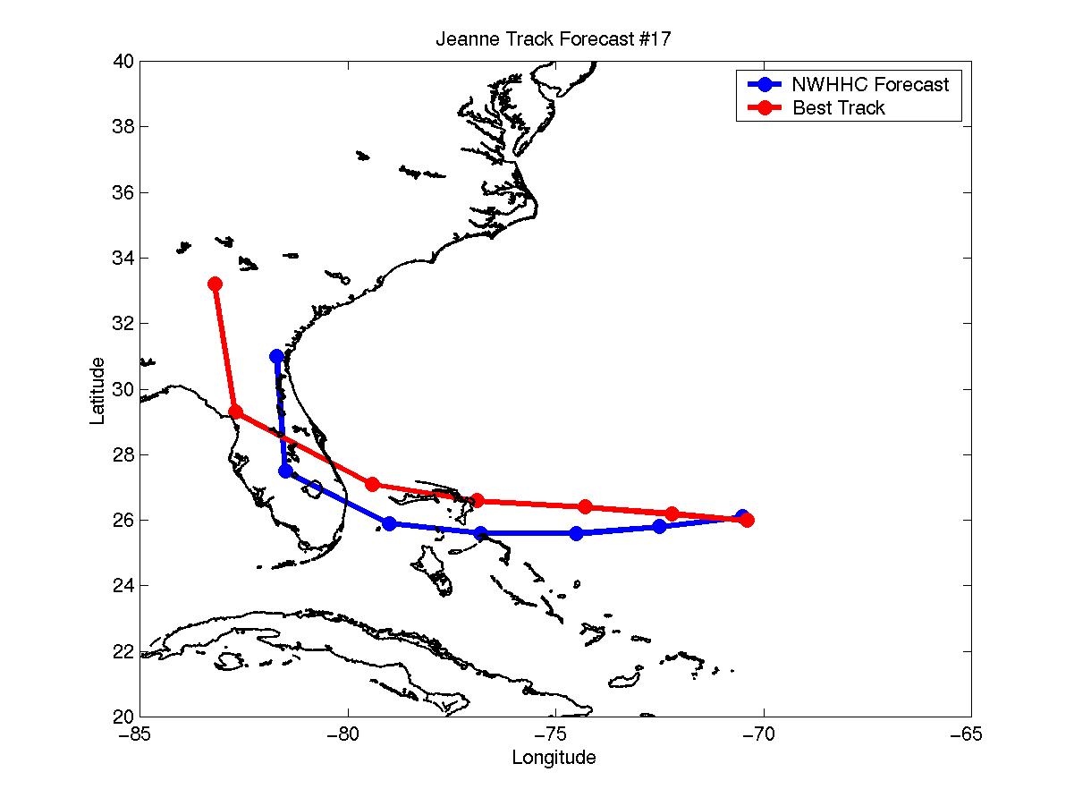
Figures 2 and 3: Selected Track Forecasts for Hurricane Jeanne
Table of Recommended Watches and Warnings
9/14 1500 UTC Tropical Storm Warning: Virgin Islands and Puerto Rico
9/14 2100 UTC Hurricane WARNING:Virgin Islands and Puerto Rico
9/14 2100 UTC Hurricane Watch: North Coast of Dominican Republic
9/15 1500 UTC Hurricane WARNING: North Coast of Dominican Republic
9/15 1500 UTC Hurricane Watch: North Coast of Haiti
9/15 2100 UTC Hurricane Watch: SE Bahamas
9/16 0600 UTC Hurricane WARNING: SE Bahamas
9/16 0600 UTC Hurricane Watch: Central Bahamas
9/16 0600 UTC Hurricane Warning Dropped: Virgin Islands and Puerto Rico
9/16 1500 UTC Hurricane WARNING: North Coast of Haiti
9/16 2100 UTC Hurricane Warning to Tropical Storm Warning: All areas
9/16 2100 UTC Tropical Storm Warning: Remainder of Hispaniola
9/17 2100 UTC Hurricane Watch Dropped: Central Bahamas
9/17 2100 UTC Tropical Storm Warning Dropped: Hispaniola
9/18 2100 UTC Tropical Storm Warning Dropped: SE Bahamas
9/23 2100 UTC Hurricane Watch: NW Bahamas
9/24 0900 UTC Hurricane WARNING: NW Bahamas
9/24 0900 UTC Hurricane Watch: Marathon, FL to Daytona beach, FL (including lake Okeechobee
9/24 2100 UTC Hurricane WARNING: Key Largo, FL to Vero Beach (including Lake Okeechobee
9/24 2100 UTC Hurricane Watch Extended: North of Daytona to St Augustine, FL
9/24 2100 UTC Hurricane Watch: Florida West Coast south of Yankeetown
9/25 0900 UTC Hurricane WARNING Extended: North of Vero Beach to Melbourne, FL
9/25 1000 UTC Hurricane WARNING Extended: Melbourne to Daytona Beach, FL
9/25 1200 UTC Hurricane WARNING: West Coast of Florida south of Yankeetown
9/25 1200 UTC Hurricane Watch: Yankeetown to Apalachicola, FL
9/25 1700 UTC Hurricane Watch Dropped: South of Key Largo
9/25 1930 UTC Hurricane WARNING Extended: North of Daytona to St Augustine
9/25 1930 UTC Tropical Storm Warning: St Augustine to Jacksonville
9/26 0300 UTC Hurricane WARNING Extended: West coast to St Marks
9/26 0300 UTC Hurricane Warning to Tropical Storm Warning: Fl east coast south of Ft Lauderdale and West Coast south of Sanibel Island
9/26 0400 UTC Hurricane Warning Dropped: NW Bahamas
9/26 0900 UTC Hurricane WARNING Extended: St Marks to Apalachicola, FL
9/26 0900 UTC Tropical Storm Warning Dropped: All
9/26 1500 UTC Hurricane Warning Dropped: FL East Coast
9/27 0300 UTC Hurricane Warning to Tropical Storm Warning: All
9/27 0300 UTC Tropical Storm Warning Dropped: South of Cedar Key
9/27 1000 UTC Tropical Storm Warning Dropped: All
Back to Verification Index