Hurricane Ivan Forecast Verification
Written by Derek Ortt on March 1, 2005
Hurricane Ivan was, in general, a well-forecast hurricane. The track errors were well below average. Overall, Hurricane Ivan was one of the easier storms to forecast as demonstrated by the CLIPER forecasts, which were also below the 10-year average error.
While Hurricane Ivan was located to the east of the Lesser Antilles, the track forecasts were very good. For each of the first six track forecasts, the 120 hour track error was more than 50 percent below the long-term average error (only three years for 120 hour forecasts), with very small errors for the other time periods. In fact, all track forecasts for Hurricane Ivan as it was located to the east of the Caribbean indicated that the hurricane would move through the Windward Islands. There was very high confidence in this forecast,d espite the model consensus indicating a threat to the Leeward Islands. The reason was that the subtropical ridge to the north was holding and there were no synotpic features that indicated any change in the ridge position and or intensity.
Track forecasts were somewhat poorer as Ivan was located in the eastern and central Caribbean. As was the case with many other storms during the 2004 season, the main source of error was forward speed, not heading. The reason for the faster track was the belief that the first trough over the week-end of Sept 11 and 12 would capture Ivan and bring the storm into the Florida Panhandle Coast. Instead, a small ridge was located near Grand Cayman Island, which prevented a quick turn to the north. Ivan was eventually captured by the next trough. It should be noted that the models, in particular the GFS, were horrible during this period, with the GFS even indicating a track east of Miami, through the central Bahamas.
After moving by Grand Cayman Island, the track forecast errors again decreased as the synoptic reasoning became simpler and there was a better model consensus. The forecast 48 hours before the near miss of Cuba had a 48 hour error of 0NM. Thus, a perfect forecast was provided for the Cuban direct hit 48 hours in advance. The next forecast provided a 72 hour error of 27NM. This forecats was issued just 78 hours before landfall. As the storm neared Alabama, the 72 hour forecast error was incorrectly indicating a stalling over the Appalachian Mountains.
Intensity forecasts were generally average, except for the longer time periods. Intensity forecasting for a storm of the intensity of Ivan is very difficult as eye wall replacement cycles are not well understood, and operational models cannot yet predict them. Ivan was forecast to impact all areas as a major hurricane well in advance, which is what occurred. In this regard, the intensity forecasting for Ivan can be considered to be a success.
The recommended watches and warnings provided by NWHHC were done so in a timely manner and for the appropriate locations. This includes the recommendation of a super hurricane warning (which is not officially issued by the National Hurricane Center) for Grand Cayman Island, as well as for extreme western Cuba. While sustained category five winds were not recorded (in the case of Grand Cayman, the storm had weakened to a very strong category four hurricane as the eye wall moved across the island), wind gusts did exceed category five velocity, and sustained winds of 130KT were recorded at Grand Cayman. These recommendations were appropriate.
For the synotpic history, meteorological statistics, best track, and official watches and warnings, please see the National Hurricane Center Tropical Cyclone Report
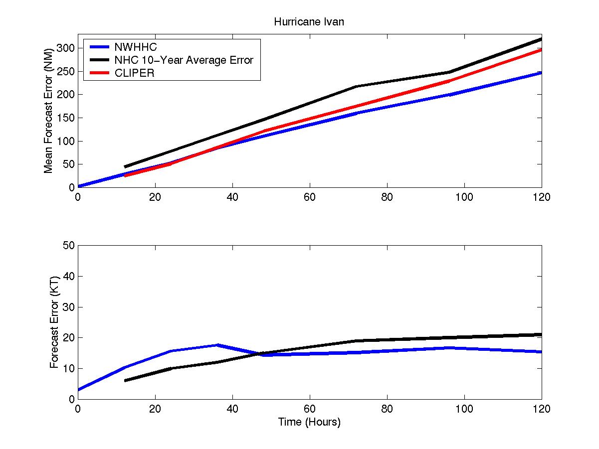
Average track and intensity forecast errors for Hurricane Ivan
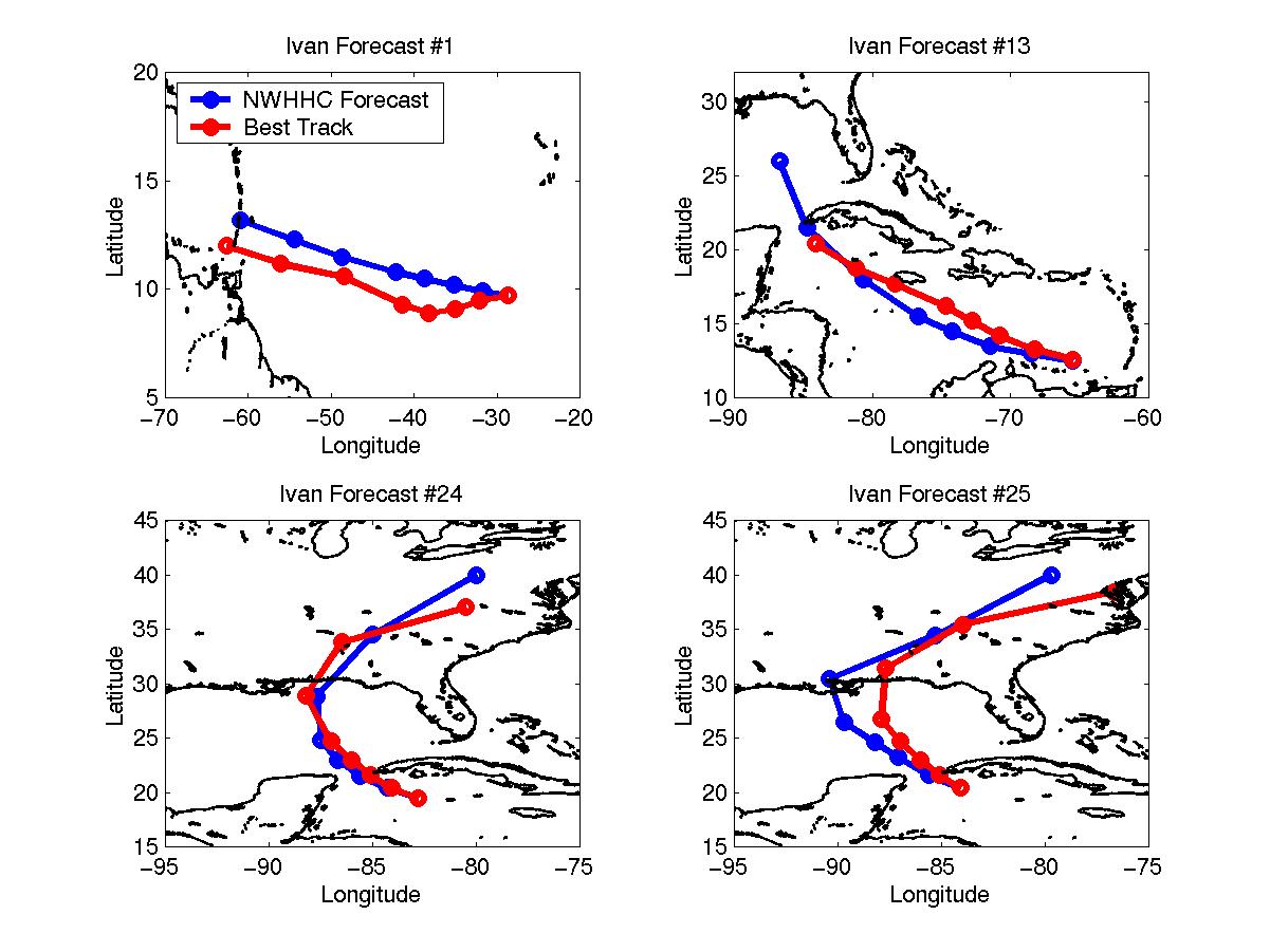
Selected track forecasts for Hurricane Ivan
Click Here for the forecast error statistics
Table of Recommended Watches and Warnings
9/5 2100 UTC Hurricane Watch: Barbados
9/6 0300 UTC Hurricane WARNING: Barbados
9/6 0300 UTC Hurricane Watch: Barbados
9/6 0900 UTC Hurricane WARNING All Windward Islands south of Dominica
9/7 0000 UTC Hurricane WARNING North coast of Venezuela east of 65W and all offshore islands east of 65W
9/7 0000 UTC Hurricane Watch Dropped: Dominica to Guadeloupe
9/7 0500 UTC Hurricane Watch: Venezuela north coast from 65 to 70W and the ABC Islands
9/7 0500 UTC Hurricane Warning Dropped: Venezuela east of 61W
9/7 1500 UTC Hurricane WARNING Extended: Venezuela to 67W
9/7 2100 UTC Hurricane WARNING Extended: Venezuela to 70W and the ABC Islands
9/7 2100 UTC Hurricane Watch: North Coasts of Venezuela and Columbia from 70 to 73W
9/8 0000 UTC Hurricane Warning Dropped: Barbados
9/8 0300 UTC Hurricane Warning Dropped: Remainder of Windward Islands, Venezuela from 61 to 62W
9/8 0900 UTC Hurricane Warning Dropped: Venezuela from 62-63W
9/8 1200 UTC Hurricane WARNING extended: to Venezuela/Columbia Border
9/8 1200 UTC Hurricane Warning Dropped: Venezuela from 63-64W
9/8 1500 UTC Hurricane Warning Dropped: Venezuela from 64-68W
9/8 1645 UTC Hurricane Watch: Jamaica
9/9 0900 UTC Hurricane WARNING: Jamaica
9/9 0900 UTC Hurricane Watch: Cayman Islands
9/9 0900 UTC All Watches/Warnings Dropped: South America, and ABC Islands
9/9 1200 UTC Tropical Storm Warning: South Coast of Haiti and Dominican Republic west of 70W
9/9 2100 UTC Hurricane WARNING Cayman Islands
9/10 0300 UTC Hurricane Watch: South coast of Cuba from 75-78W
9/10 1200 UTC Hurricane WARNING South Coast of Cuba from 75-78W
9/10 1500 UTC Hurricane Watch: All of Cuba from 78-84W
9/10 1500 UTC Tropical Storm Warning Dropped: Dominican Republic
9/11 0900 UTC Tropical Storm Warning Dropped: Haiti
9/11 1500 UTC Hurricane WARNING All of Cuba from 80-84W
9/11 1500 UTC Hurricane Warning Dropped: Cuba from 75-78W
9/11 2000 UTC SUPER HURRICANE WARNING: Grand Cayman Island
9/12 0300 UTC Hurricane WARNING extended: All of Cuba west of 80W
9/12 0300 UTC Hurricane Warning to Tropical Storm Warning: Jamaica
9/12 0300 UTC Hurricane Watch Dropped: Cuba from 78-80W
9/12 1500 UTC Hurricane Watch: Yucatan east coast from Mexico/Belize Border to Cancun
9/12 1500 UTC Tropical Storm Warning Dropped: Jamaica
9/12 1800 UTC Super Hurricane Warning to Hurricane Warning: Grand Cayman
9/12 2100 UTC Hurricane Watch/Tropical Storm Warning: Belize/Mexico Border to Cancun
9/12 2100 UTC Hurricane Watch: Cancun to Merida
9/12 2100 UTC Hurricane Warning Dropped: Cuba from 80-82W
9/13 0000 UTC Hurricane WARNINGCozemul to Merida
9/13 1630 UTC SUPER HURRICANE WARNING All of Cuba west of 84.5W
9/13 1630 UTC Hurricane Warning Dropped: Cayman Islands
9/13 2100 UTC All watches and warnings dropped: South of Cozemul
9/14 0300 UTC Hurricane Watch: Grand Isle, Louisiana to Panama City, Florida
9/14 0900 UTC Super Hurricane Warning to Hurricane Warning: Cuba west of 84.5W
9/14 0900 UTC Hurricane Warning Dropped: Cuba from 82-83W and from Cozemul to Merida
9/14 1500 UTC Hurricane WARNINGMississippi/Louisiana Border to Panama City
9/14 1500 UTC Hurricane Watch Extended: Grand Isle border to Morgan City, Louisiana
9/14 2100 UTC Hurricane WARNING extended: west to Grand Isle
9/15 0000 UTC Hurricane Warning Dropped: Cuba
9/15 1800 UTC Hurricane WARNING extended: east to Cedar Key
9/16 0500 UTC Hurricane Watch Dropped: Grand Isle to Morgan City
9/16 1500 UTC All Watches and Warnings Dropped
9/23 2100 UTC Tropical Storm Warning: Cameron, Louisiana to Galveston, Texas
924 0300 UTC Tropical Storm Warning Dropped
Back to Verification Index