Hurricane Frances Forecast Verification
Written by Derek Ortt on May 26, 2005
Track forecasts for Hurricane Frances were, in general, outstanding. Forecast errors were well below those of the long-term average and as much as 60-70 percent better than the CLIPER, especially at the longer time periods. That said, there were some forecast problems that did arise. The first of which was in the initial forecasts where forecast models had the storm recurving into the open Atlantic, well east of the Caribbean. This did not happen as a ridge, not a trough, developed to the north of the hurricane. The second error was bringing the storm too close to the Leeward Islands, which led to NWHHC recommending a Hurricane Warning for the area. The third was not anticipating the slowdown in the Bahamas and the fourth was bringing the storm too far west in the Gulf of Mexico.
The intensity forecasts, on the other hand, were merely average with the mean errors verifying close to the long-term average. The initial forecasts did not indicate that Frances would intensifying beyond category 1 status, while other forecasts had problems detecting the eye wall replacement cycles. There is little skill in forecasting these processes; thus, significant error can be expected. The other main source of error was not forecasting the weakening over the Bahamas. The increase in wind shear to roughly 25-30KT was not expected. This also resulted in over-forecasts for the Gulf of Mexico as a landfalling category four hurricane was expected for the east coast, which would have allowed Frances to maintain hurricane intensity across the state.
While the watches and warnings that were recommended by NWHHC were for the correct locations, with the already stated exception being the Leeward Islands, they were often issued too early. The most notable case of this is the east coast of Florida, where a Hurricane Warning was recommended at 1800 UTC, Sept 2. This was about 60 hours prior to landfall and about 45 hours prior to the onset of hurricane winds. This was due to not anticipating the slowdown. In retrospect, a Hurricane Watch could have been recommended for the east coast of Florida at 1500 UTC, Sept 2, and a Warning at either 0300 UTC or 0900 UTC the next day.
For synoptic history, as well as official watches and warnings, please see the National Hurricane Center Tropical Cyclone Report for Hurricane Frances
Click Here for the forecast error statistics
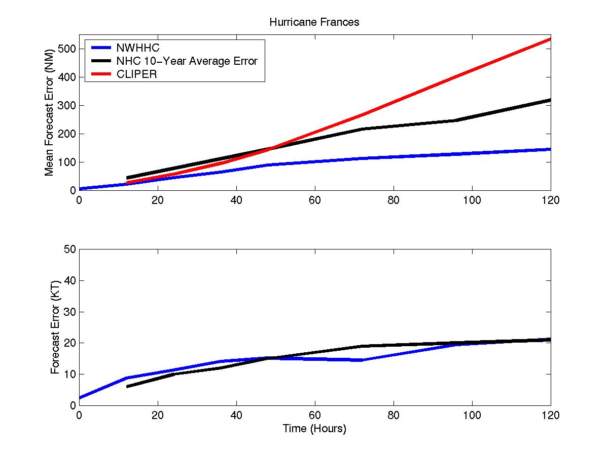
Mean track (top) and intensity (bottom) errors for Hurricane Frances
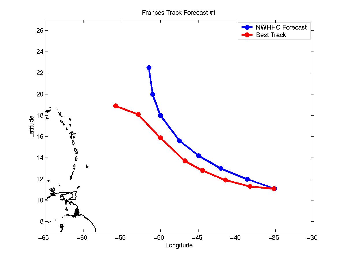
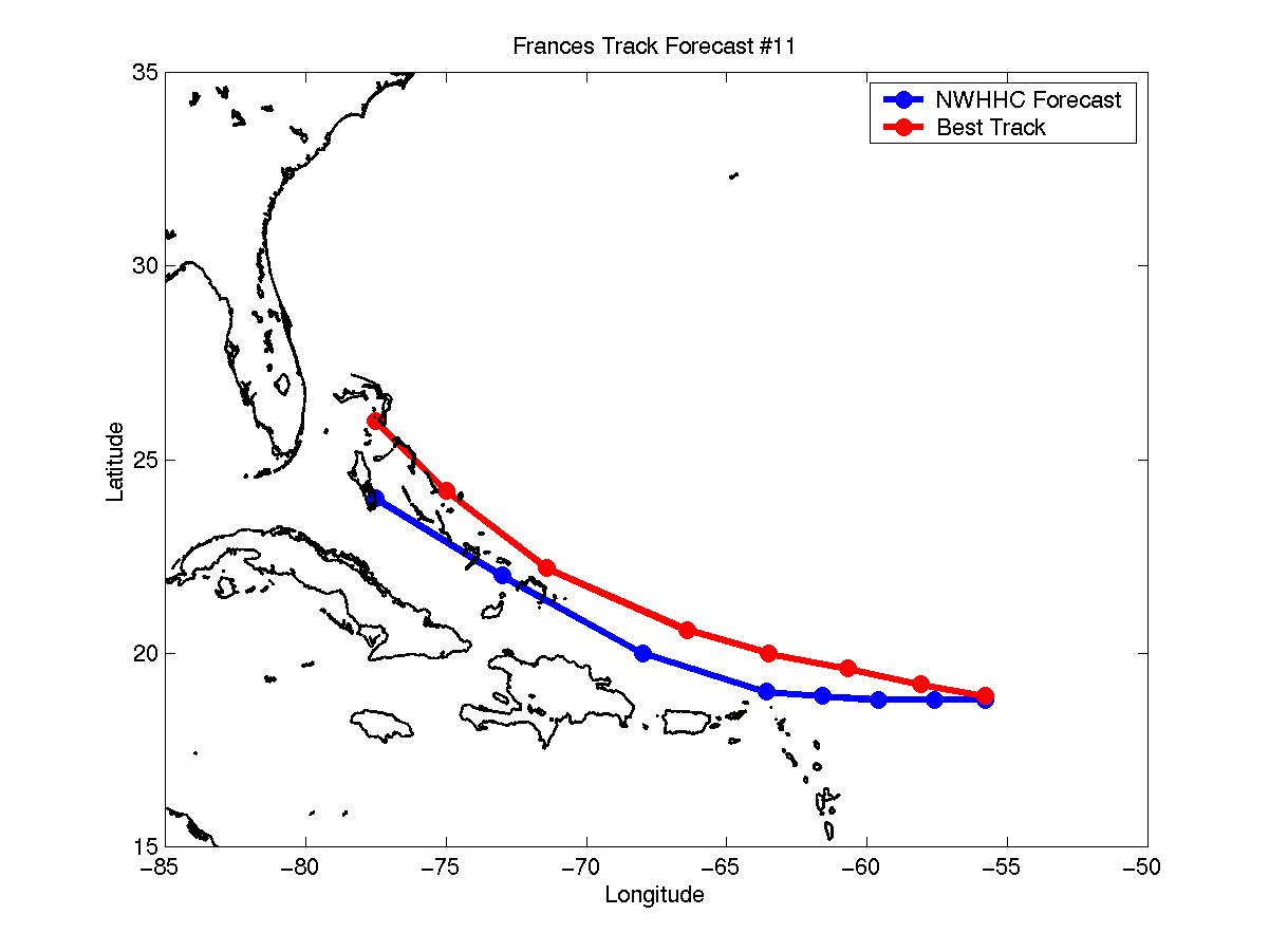
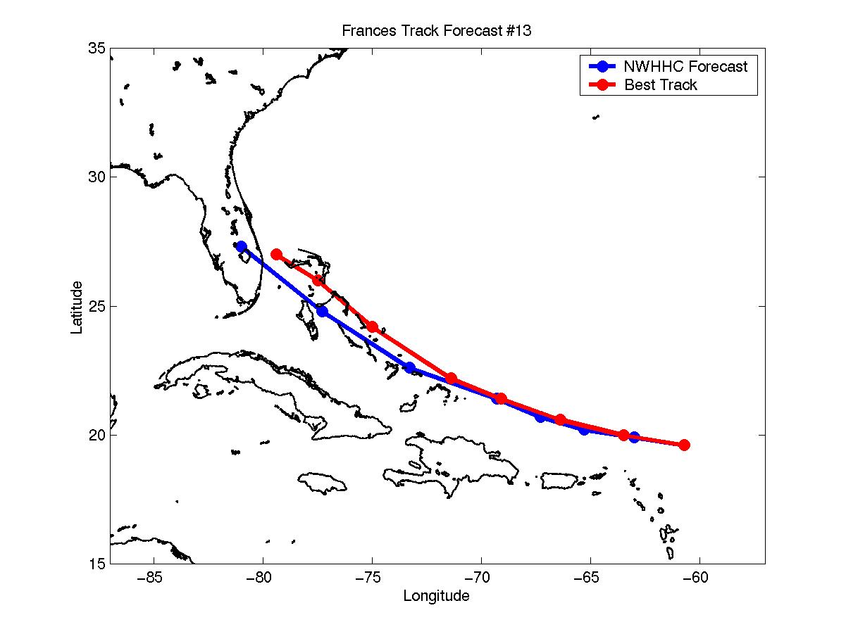
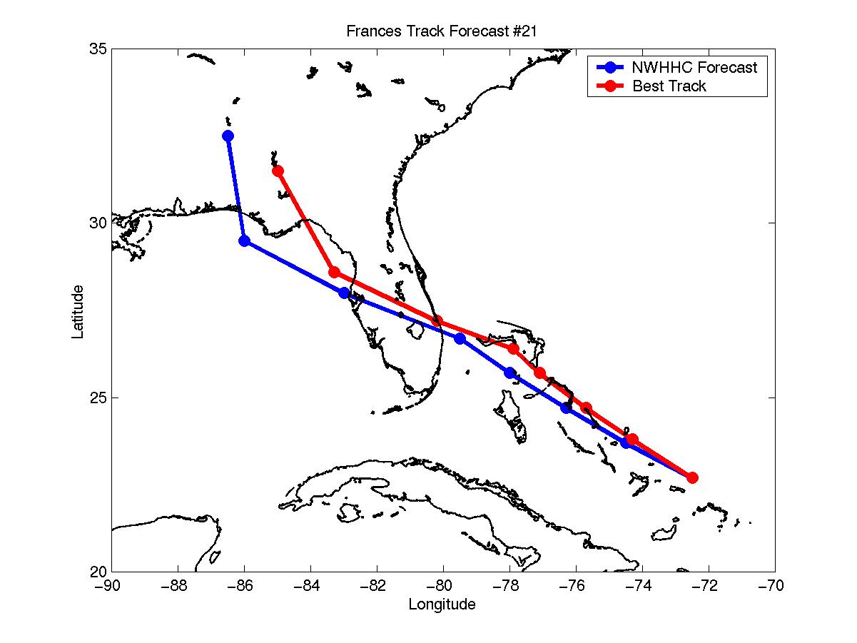
Selected track forecasts for Hurricane Frances
Table of Recommended Watches and Warnings
8/29 2100 UTC Hurricane Watch: Leeward Islands north of Antigua
8/30 0900 UTC Hurricane Watch/Tropical Storm Warning: Leeward Islands north of Antigua
8/30 0900 UTC Hurricane Watch: Virgin Islands
8/30 1500 UTC Hurricane WARNING: Leeward Islands north of Antigua and Virgin Islands
8/30 1500 UTC Hurricane Watch: Puerto Rico
8/31 0000 UTC Hurricane Watch/Tropical Storm Warning: Puerto Rico
8/31 0900 UTC Hurricane Watch: SE Bahamas
8/31 0900 UTC Hurricane Watches and Warnings Dropped: Caribbean
8/31 0900 UTC Tropical Storm Warning: Puerto Rico and Virgin Islands
8/31 1600 UTC Hurricane WARNING: SE Bahamas
8/31 1600 UTC Hurricane Watch: Central Bahamas and north coast of Dominican Republic
8/31 2100 UTC Hurricane WARNING: Central Bahamas
8/31 2100 UTC Hurricane Watch to Tropical Storm Warning: North coast of Dominican Republic
8/31 2100 UTC Tropical Storm Warning Dropped: Virgin Islands and Puerto Rico
9/1 1500 UTC Hurricane Watch: NW Bahamas
9/2 0900 UTC Hurricane WARNING: NW Bahamas
9/2 0900 UTC Hurricane Watch: Key Largo, FL to St Augustine, FL including Lake Okeechobee
9/2 0900 UTC Tropical Storm Warning Dropped: Dominican Republic
9/2 1500 UTC Hurricane Warning Dropped: Turks and Caicos Islands in SE Bahamas
9/2 1800 UTC Hurricane WARNING: Dade/Broward County Line to Daytona Beach, FL including Lake Okeechobee
9/2 2100 UTC Hurricane Watch: West coast of FL from Sanibel Island to Horseshoe Beach
9/3 1200 UTC Hurricane Warning Dropped: SE Bahamas
9/3 1500 UTC Hurricane Watch/Tropical Storm Warning: Dade/Broward Line to Key Largo and Daytona Beach to Jacksonville
9/4 0900 UTC Hurricane Warning Dropped: Central Bahamas
9/4 1200 UTC Hurricane WARNING Extended: North of Daytona Beach to St Augustine
9/4 1500 UTC Hurricane Watch/Tropical Storm Warning: FL West Coast from Sanibel Island to Horseshoe Beach
9/4 1700 UTC Hurricane WARNING: FL West Coast from Sanibel Island to Horseshoe Beach
9/5 1000 UTC Hurricane Warning Dropped: NW Bahamas
9/5 1500 UTC Hurricane Warning Dropped: South of Sarasota
9/5 1500 UTC Hurricane Watch Dropped: East Coast Watch Areas
9/5 1500 UTC Hurricane Warning to Tropical Storm Warning: South of Palm Beach
9/5 1800 UTC Hurricane WARNING:Sanibel Island to Florida/Alabama Border
9/5 2100 UTC All Watches and Warnings Dropped: FL East Coast and Lake Okeechobee
9/6 0300 UTC Hurricane Warning Dropped: South of Tampa
9/6 0900 UTC Hurricane Warning Dropped: South of Yankeetown
9/6 1500 UTC Hurricane Warning Dropped: All
9/6 1500 UTC Tropical Storm Warning: Cedar Key to Apalalachicola, FL
9/6 2100 UTC Tropical Storm Warning Dropped: All
Back to Verification Index