Hurricane Charley Forecast Verification
Written by Derek Ortt on April 3, 2005
Hurricane Charley was a difficult storm to forecast due to its fast motion, its recurvature, as well as its acceleration up the U.S. East Coast.
Track forecasts through 72 hours for Hurricane Charley are slightly below the long-term averages. However, the 96 and 120 hour forecasts were very poor. All time periods fared better than the CLIPER. It should be noted that only the very first forecast had a verifying 120 hour forecast, and there were only 4 verifying 96 hour forecasts. All of these were prior to the forecasts indictaing recurvature. Future forecasts were far better, correctly indicating a landfall south of Tampa, as well as a final landfall in the Carolinas. it needs to be stated that within 48 hours of Florida landfall, landfall forecasts typically had errors less than 100NM and all forecasts showed a landfall south of Tampa.
Intensity forecasts were somewhat above average. The main culprit of this was a special forecast issued at 2100 UTC, 8/11. Ship reports that afternoon indicated that Charley had degenerated into a wave. Therefore, the intensity forecast was significantly reduced. Late afternoon recon data showed this was not the case and that Charley merely had a very small vortex. Future intensity forecasts were revised upwards. It needs to be noted that all intensity forecasts, except for the special forecast, indicated a landfalling category 2 or higher storm. Landfall intensity forecasts for the Carolinas were also good in that every forecast, except for a special forecast issued at 1800 UTC on 8/13 indicated a category 1 landfall. The special forecast indicated a marginal cat 2. This could have happened had Charley not have been losing tropical characteristics as it was moving into South Carolina. The flight level wind reduction typically would have indicated an 80KT storm at landfall. Cuba landfall forecasts also generally indicated a category 2 or 3 hurricane at landfall. It needs to be noted that operationally, Charley was carried as a cat 2 across Cuba. it was not until surface observations became available that it was known that Charley was in fact a category 3. it needs to be noted that during this time, the 700mb winds were less than the surface winds.
Recommended Watches and Warnings were issued accordingly. Cuba received more than 36 hours of lead time for the recommended warning. The FL landfall zone received about 30, the East Coast of FL about 18, and the Carolinas about 24.
There was a lot of complaints regarding the forecasts for Hurricane Charley by residents in the Florida landfall zone. Very few of these claims were valid. First, the area was under an OFFICIAL HURRICANE WARNING Second, the Official National Hurricane Center Forecasts brought the hurricane very close to Charlotte Harbor. Third, NWHHC forecasts consistently indicated a landfall near the Charlotte Harbor. Therefore, the lack of preparation for conditions through a category 3 hurricane is strictly the fault of the residents of the area. For those who did prepare for a category three hurricane, the lack of preparation for a category four hurricane lies more with the forecaster for not clearly stating the possibility that Charley could become a category four hurricane.
For synoptic history, as well as the official watches and warnings, please view the National Hurricane Center Tropical Cyclone Report for Hurricane Charley.
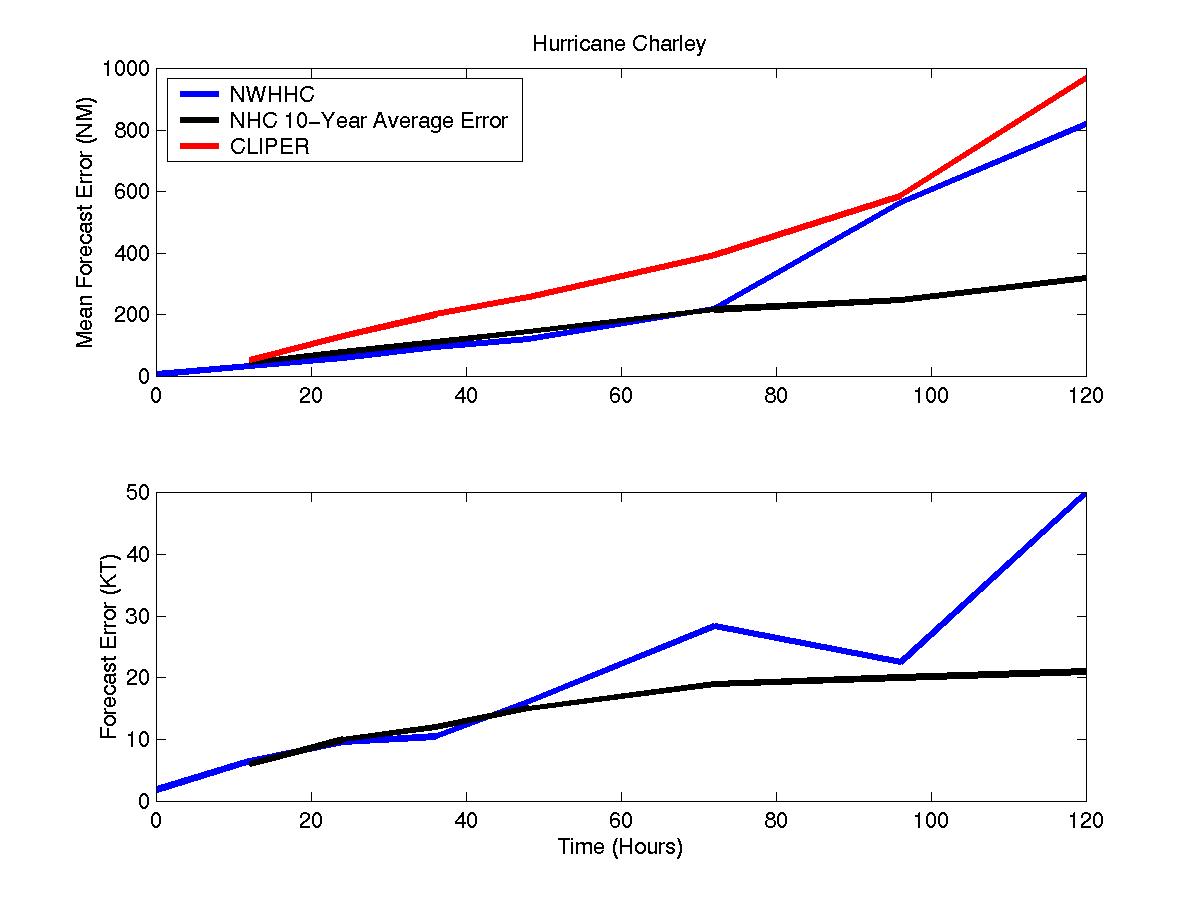
Mean track and intensity forecast errors for Hurricane Charley
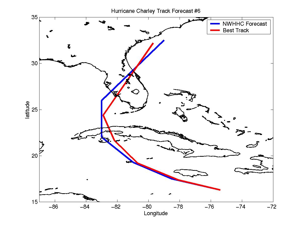
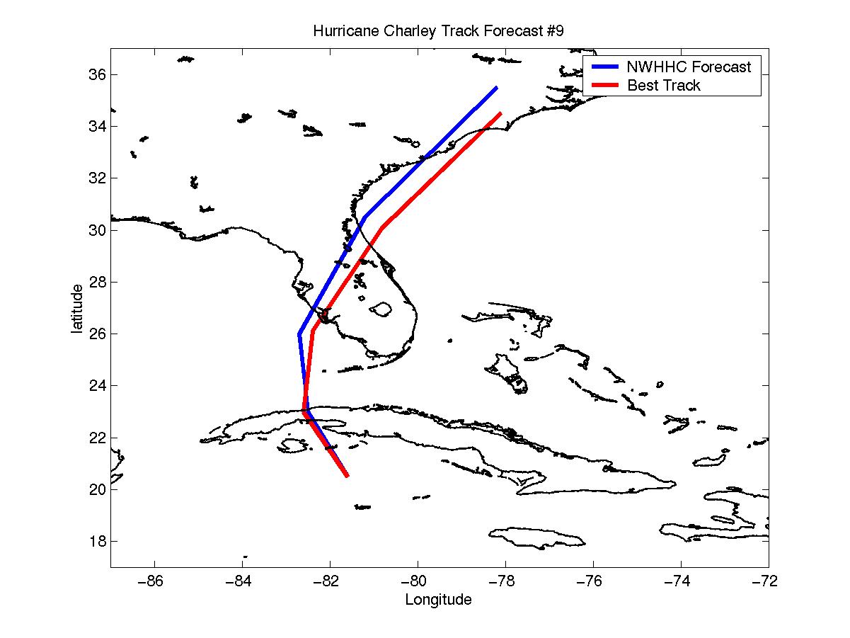
Selected track forecasts for Hurricane Charley
Click Here for the Hurricane Charley Error Statistics
Table of Recommended Watches and Warnings
8/11 0000 UTC Hurricane WARNING: Jamaica
8/11 0000 UTC Hurricane Watch: Cayman Islands
8/11 0300 UTC Hurricane WARNING: Cayman Islands
8/11 0300 UTC Hurricane watch: Cuba west of 81W
8/11 1200 UTC Hurricane Watch Extended: Cuba west of 80W
8/11 1200 UTC Hurricane Watch: Dry Tortugas to Marathon, FL
8/11 1500 UTC Hurricane WARNING: Cuba from 81-85W
8/11 2100 UTC Hurricane Watch Extended: North of Marathon, along West Coast of FL to Naples
8/12 0000 UTC Hurricane Watch Extended: North to Ft Myers
8/12 0300 UTC Hurricane Watch Extended: North to Sarasota
8/12 0900 UTC Hurricane WARNING: Dry Tortugas to Marathon
8/12 0900 UTC Hurricane Watch Extended: North to Yankeetown
8/12 0900 UTC Hurricane Warning Dropped: Jamaica
8/12 1200 UTC Hurricane WARNING Extended: Marathon to Ft Myers
8/12 1500 UTC Hurricane WARNING Extended: North to Tampa
8/12 1500 UTC Hurricane Watch: Florida East Coast from Daytona Beach to Jacksonville
8/12 1800 UTC Hurricane WARNING Extended: North to Yankeetown
8/12 2100 UTC Hurricane Watch: Key Largo to Marathon
8/12 2100 UTC Hurricane Watch Extended: North to Savannah, GA
8/12 2100 UTC Hurricane Warning Dropped: Cayman Islands
8/13 0600 UTC Hurricane Watch Extended: South to Melbourne
8/13 0600 UTC Tropical Storm Warning: Lake Okeechobee
8/13 0900 UTC Hurricane WARNING: Daytona beach to Savannah
8/13 0900 UTC Hurricane Watch: Savannah to Myrle Beach, SC
8/13 0900 UTC All Watches and Warnings Dropped: Cuba
8/13 0900 UTC Hurricane Watch Dropped: Key Largo to Marathon
8/13 1100 UTC Hurricane Watch Extended: North to Cape Fear
8/13 1300 UTC Hurricane WARNING Extended: North to Myrtle Beach
8/13 1300 UTC Hurricane Watch Extended: North to Cape Hatteras
8/13 1500 UTC Hurricane Watch Extended: North to North Carolina/Virginia Border
8/13 1700 UTC Hurricane WARNING Extended: To NC/Virginia Border
8/13 1700 UTC Hurricane Warning Dropped: Florida Keys
8/13 2100 UTC Hurricane Warning Dropped: north of Tampa
8/14 0000 UTC All Watches and Warnings Dropped: Florida West Coast and Lake Okeechobee
8/14 0900 UTC Hurricane Warning Dropped: South of Savannah
8/14 0900 UTC Tropical Storm Warning: NC/VA Border to Delaware Bay
8/14 1200 UTC Hurricane WARNING Extended: to Delaware Bay, including Chesapeake Bay south of Smith Point
8/14 1200 UTC Tropical Storm Warning: North of Smith Point for Chesapeake Bay
8/14 1500 UTC Hurricane Warning Dropped: South of Charleston, SC
8/14 1800 UTC Hurricane Warning Dropped: Entire East Coast
8/14 1800 UTC Tropical Storm Warning: Cape Fear, NC to Atlantic City, NJ
8/14 2100 UTC Tropical Storm Warning Extended: North to Watch Hill, RI
8/14 0000 UTC Tropical Storm Warning Dropped: South of Virginia Beach
8/14 0300 UTC Tropical Storm Warning Dropped: South of NYC
8/14 0900 UTC Tropical Storm Warning Dropped: Remainder of East Coast